Route Editor

| Guide | ♦ | 4 Triplogs | 0 Topics |
details | drive | permit | forecast | route |
stats |
photos | triplogs | topics | location |
| 55 | 4 | 0 |
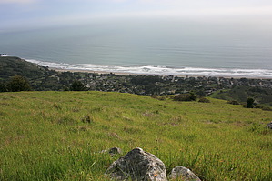
Quite Possibly the Most Spectacular Hike in Marin by JimmyLyding There are two ways to do this lasso loop. The most popular way is to start at the Pantoll Ranger Station, but savvy hikers begin their journey at the Trojan Point parking area. Pantoll has the full suite of facilities: bathrooms, water, picnic tables, etc. It also costs $8.00 to park there, and you'll be lucky to find a spot. Trojan Point offers free parking, and you'll have no trouble finding a spot. Figure out what works for you.
Hikers who elect not to pay for the convenience of having a vault toilet and trash cans start at Trojan Point parking area. If you choose this option do not miss the opportunity of venturing a few hundred yards south-southeast up from the parking area for a view that may be the best in the entire Bay Area. The hike begins by crossing Pantoll Road (which takes you to Trojan Point from the ranger station) to an unofficial trail that is easy to find. This trail is a single track that basically follows the contour of the ridge about 200 vertical feet above the Matt Davis Trail. There is a fork in the trail about 1/3 mile in, and you want to veer left (i.e. towards the ocean). You pass a sizable spring, and like Matt Davis, travel through open grassland interspersed with small copses of trees. When you reach the first deep drainage you want to head downhill. There is a continuation of this unofficial trail that heads uphill before crossing the drainage, but it was blocked by fallen trees when I was there today. A few hundred yards downhill is the junction with the Matt Davis Trail. A few hundred yards west of this junction the Matt Davis Trail heads downhill towards Stinson Beach while the Coastal Trail begins and heads along the contour to the north. Take the Coastal Trail. You will continue through the same terrain: open grassland that features spring wildflowers, deep Douglas fir forest below you, and expansive views of the Pacific Ocean. You will undoubtedly see many birds of prey soaring overhead. 1.6 miles north from the junction you reach the Willow Camp Fire Road which heads west down to Stinson Beach. You climb a small hill that provides a great view north of Bolinas Lagoon, the San Andreas Rift Zone, and the southern part of Point Reyes National Seashore. Willow Camp Fire Road soon heads downhill through a deep forest of Douglas fir, tanoak, and California bay. This forest is a classic Pacific coast forest with tree branches arcing away from the coast due to the constant wind and lots of fungi, lichen, and moss. This trail has some fairly steep stretches, but isn't too taxing. The vegetation changes to coastal chaparral about 500 feet above sea level. The wildflowers here are noticeably different from what you saw higher up on the ridge. Purple mission bells, white & pink beach morning glory and white cow parsnip replace California poppies, thistle, and lupine. You may be lucky enough to find a beach strawberry, but the extensive local deer population typically takes care of those before you'd get the chance. The Willow Camp Fire Road ends at the residential street Avenida Farallone. Walk down this street past houses that are straight out of Sunset Magazine about 1/10 mile, then turn left at Belvedere. Take Belvedere 1/10 mile, then turn left up a short driveway between two houses for 200 feet to the upper Stinson Beach trailhead of the Matt Davis Trail. There is another trailhead that can be accessed by following Belvedere down to Buena Vista St. that is just uphill from the fire station. The lower portion of Matt Davis crosses Table Rock Creek through a nice mix of coastal marsh and forest of bigleaf maple and Douglas fir. This trail begins to climb in earnest soon enough. Matt Davis is very well-constructed. The steep portions have steps made of railroad ties and stone. It can be tough on one's knees, and is a great cardio workout. You cross a perennial creek (name unknown) just below Table Rock. The trail heads away from Table Rock, then switchbacks back toward it. Table Rock is right off the trail, and is a great spot for a break because there are a number of flat, smooth places to sit. The views aren't too shabby, either: the Pacific Ocean stretches out before you beyond the dense forest. Matt Davis travels roughly 1,400 feet in 2.2 miles from its lower terminus to its junction back at the Coastal Trail. Again, this is the southern end of the Coastal Trail. The Matt Davis Trail heads back towards Pantoll for the $8 parking crowd. Those of us who are cheapskates have one final treat: a steep uphill slog of 400 feet over just 0.2 mile. This segment is another unofficial trail that takes you back to the unofficial trail that heads back to Trojan Point. Turn right and head back to your vehicle. Important Note: the upper portions of this hike are on narrow trails with tall grass growing right next to the trail. Please check for ticks because you'd much rather bring back pictures, memories, and a triplog rather than Lyme disease. Check out the Official Route and Triplogs. Leave No Trace and +Add a Triplog after your hike to support this local community. | ||||||||||||||||||||||||||||||||||||||||||||||||||||||||||||||||||||||||||||||||||||||||||||||||