username
X
password
register
for free!
help
  

Dry Creek Falls, OR

Guide 5 Triplogs  0 Topics
  4 of 5  
Fav
Wish
0
details
drive
permit
forecast
route  
stats
photos
triplogs
topics
location
34 5 0
Statistics
tap row or icons for details
Difficulty 2.5 of 5
Route Finding 1 of 5
Distance Round Trip 5 miles
Trailhead Elevation 56 feet
Elevation Gain 703 feet
Accumulated Gain 913 feet
Avg Time Round Trip 2 hours
Kokopelli Seeds 9.57
 Interest Perennial Waterfall & Perennial Creek
 Backpack Connecting Only
feature photo
Photos Viewed All MineFollowing
Inaugural Calculation on Button Tap!
4  2021-10-28 Eartheist
9  2014-07-20 skatchkins
8  2011-05-01 sagamihara_hiker
13  2010-04-18 sagamihara_hiker
Author
author avatar Guides 15
Routes 265
Photos 3,881
Trips 366 map ( 2,529 miles )
Age 52 Male Gender
Location Sagamihara, Japan
Associated Areas
list map done
North Central Region
Historical Weather
Trailhead Forecast
Radar Map
Expand Map
Preferred May, Oct, Jun, Apr
Seasons   ALL
Sun  5:35am - 6:36pm
Official Route
 
0 Alternative


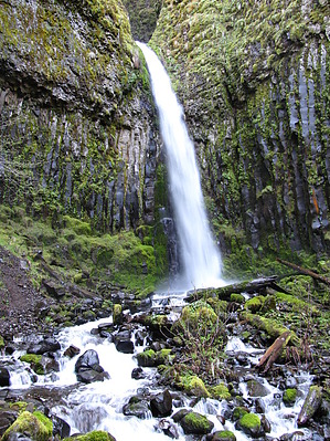
Lesser known falls in the Gorge
by sagamihara_hiker

This hike starts at the Bridge of the Gods Trailhead. From the trailhead, cross the road and head up the Pacific Crest Trail parallel to I-84. In about 1/10 of a mile, you'll come to Moody Street as it crosses under the freeway. Walk the road uphill to the right for a bit, under the freeway. When the road angles left, go straight ahead on a gravel road a short distance to twin trailheads. Altogether the road walking here is about 100 yards. The trail to the right is the Gorge Trail headed toward the Ruckel Creek Trail and the Eagle Creek Campground. You'll take the trail to the left, which is the Pacific Crest Trail.


The Crest Trail heads gradually uphill, never too steep, through a pretty, dappled sun kind of forest. In the spring, forest wildflowers including columbines are common here. About 1 mile in, you'll come to a powerline access road. Turn right here and follow the road a short distance under the powerlines to the resumption of the trail. Soon after the powerline road, you'll come to a minor summit and the trail begins a gradual descent to Dry Creek. On a clear day, look for views of Mt. Adams through the trees. This section of trail heads gradually downward through an interesting area of large lava boulders and trees for almost another mile.
remove free decal offer
At Dry Creek, the trail comes to another dirt road. This one seems to be open to normal traffic, at least I've seen tires tracks before. The Crest Trail crosses the road and then crosses Dry Creek on a wooden bridge. To get to Dry Creek Falls, instead of crossing the bridge, turn right here and head up the road about 2/10 of a mile to the falls. At the end of the road, there's a car turnaround and a fire pit.

Although it's called Dry Creek Falls, it does not run dry - even in the warmest months of summer. There is evidence of some damming apparatus here, once used to provide water to the town of Cascade Locks, Oregon.

2011-05-01 sagamihara_hiker


    Check out the Official Route and Triplogs.
    Leave No Trace and +Add a Triplog after your hike to support this local community.
    WARNING! Hiking and outdoor related sports can be dangerous. Be responsible and prepare for the trip. Study the area you are entering and plan accordingly. Dress for the current and unexpected weather changes. Take plenty of water. Never go alone. Make an itinerary with your plan(s), route(s), destination(s) and expected return time. Give your itinerary to trusted family and/or friends.

     Permit $$
    information is in description

    Mount Hood Forest
    more info


     Directions
    or
     Road
    Paved - Car Okay

    To hike
    From Portland, drive east on I-84 to Cascade Locks. Take the first Cascade Locks exit. Drive under the Bridge of the Gods and immediately turn right on the road toward the Bridge of the Gods. Before you get to the toll booth, you'll find the trailhead lot on the right, in the center of the road loop.

    From Washington, cross the Bridge of the Gods and pay your toll in the booth. Just feet beyond the toll booth, you'll find the lot on the left.
    page created by sagamihara_hiker on May 01 2011 6:47 pm
     90+° 8am - 6pm kills
    helpcorrectionissue

    end of page marker