username
X
password
register
for free!
help


Pointe Tapatio Golf Course Loop #1, AZ

Guide 161 Triplogs  0 Topics
  2.7 of 5  
Fav
Wish
1
details
drive
no permit
forecast
route  
stats
photos
triplogs
topics
location
580 161 0
Statistics
tap row or icons for details
Difficulty 2 of 5
Distance Loop 5.2 miles
Trailhead Elevation 1,406 feet
Elevation Gain 292 feet
Accumulated Gain 860 feet
Avg Time Round Trip 2 hours
Kokopelli Seeds 9.5
 Backpack No
feature photo
Photos Viewed All MineFollowing
Inaugural Calculation on Button Tap!
5  2025-04-05
N Mountain Shaw Butte Area
diablo
2  2019-10-08 kingsnake
11  2019-05-12
Lookout Mountain Connector #25
Nate_F
3  2018-01-17 kingsnake
2  2018-01-03 kingsnake
1  2017-05-05 kingsnake
4  2017-03-18 kingsnake
3  2016-01-06 kingsnake
Page 1,  2,  3,  4,  5 ... 9
Author
author avatar Guides 116
Routes 337
Photos 11,399
Trips 894 map ( 8,139 miles )
Age 63 Male Gender
Location Sunnyslope, PHX
Associated Areas
list map done
Phoenix Region
Historical Weather
Trailhead Forecast
Radar Map
Expand Map
Preferred Mar, Nov, Feb, Jan
Seasons   ALL
Sun  6:04am - 6:50pm
Official Route & 5 Rts
 
10 Alternative


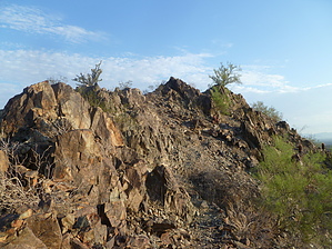
Club a golfer, save the desert
by kingsnake

 
The hike begins by dipping into a wash to look at a rusted-out old car. No idea how it got there. Then head south skirting the housing area. When you turn north into a small canyon, you begin the first of three short, but steep ascents.


At the top of that first climb, are good observation points both east and west, for viewing sunrise or sunset. Continue north descending to Trail 100 and the Sheriff's Posse corral. Turn east on Trail 100. Turn north at the first wash, then west up the steepest ascent of the hike. (130 feet in a tenth of a mile, equates to 1300 feet over a mile, or a 25% grade.)
remove free decal offer
Drop back down, then continue east up the Golf Course Ridgeline, from whence this hike draws its name. Marvel at people paying big bucks to chase small white balls. The max elevation of 1686 feet is reached at the far east end of the ridgeline. Continue east to Thunderbird, where there is a mountain preserve sign. Cross the wash, then curl around the north and east edges of the hill at Thunderbird and Cave Creek. Descend into, and cross the wash to join back up with Trail 100. Turn west. Continue west on Trail 100 until you see the housing area you began from.

Trail 100 continues along the north edge of the ridgeline, but you should take the split along the ridgeline's south edge. After a bit, the trail turns south back to the trailhead. Wildlife: Owl, coyote, javelina, fox, homeless people. (If you do the hike near sunset, keep an eye out for the owl.)

2011-05-02 kingsnake


    Check out the Official Route and Triplogs.
    Leave No Trace and +Add a Triplog after your hike to support this local community.
    WARNING! Hiking and outdoor related sports can be dangerous. Be responsible and prepare for the trip. Study the area you are entering and plan accordingly. Dress for the current and unexpected weather changes. Take plenty of water. Never go alone. Make an itinerary with your plan(s), route(s), destination(s) and expected return time. Give your itinerary to trusted family and/or friends.

     Permit $$
    None


     Directions
    or
     Road
    Paved - Car Okay

    To hike
    From Cave Creek Rd, west on Peoria Ave, 1 block. North on 12th St, about half mile until you hit a cul-de-sac. That is the trailhead. No facilities.
    page created by kingsnake on May 02 2011 12:18 pm
     90+° 8am - 6pm kills
    helpcorrectionissue

    end of page marker