username
X
password
register
for free!
help
 

Rarick Canyon, AZ

Guide 15 Triplogs  0 Topics
  4.3 of 5  
Fav
Wish
7
details
drive
no permit
forecast
map
stats
photos
triplogs
topics
location
288 15 0
Statistics
tap row or icons for details
Difficulty 2 of 5
Route Finding 2 of 5
Distance Round Trip 2 miles
Trailhead Elevation 3,974 feet
Elevation Gain 300 feet
Accumulated Gain 300 feet
Avg Time Round Trip 2 hours
Kokopelli Seeds 3.5
 Interest Off-Trail Hiking & Seasonal Creek
 Backpack Possible - Not Popular
feature photo
Photos Viewed All MineFollowing
31  2025-01-04
Rarick Canyon and Hilltop Ruins
John10s
24  2024-12-12 cactuscat
8  2024-04-17 AZLOT69
10  2020-02-11
Rarick and Mullican Canyon
MountainMatt
14  2019-11-30 MountainMatt
24  2018-11-10 eagleloc
20  2017-12-11 TheNaviG8R
68  2017-11-29 TheNaviG8R
Page 1,  2,  3
Author
author avatar Guides 77
Routes 106
Photos 2,987
Trips 57 map ( 363 miles )
Age 63 Male Gender
Location Thousand Oaks, CA
Associated Areas
list map done
Camp Verde Region
Historical Weather
Trailhead Forecast
Expand Map
Preferred Mar, Nov, Feb, Apr
Seasons   Late Autumn to Early Spring
Sun  6:03am - 6:48pm
3 Routes
 
1 Alternative


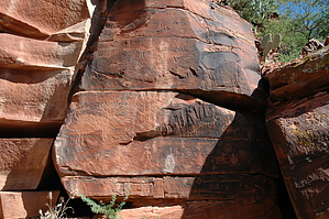
Lots of Petroglyphs
by slegal

With all of the great petroglyphs photos that have been posted over the years on HAZ, it surprised me that no one has posted any photos of this little gem. It certainly can't be a secret spot if I found it, because I live in California. Of all things, Pink Jeep Tours got me there.


Rarick Canyon is located east of I-17 off of NF-618. After a couple of dirt roads, you're above the canyon. Our trek took up down a narrow and steep trail that quickly descended into the canyon. There is a much easier way down. There are no petroglyphs on the easy route. There are petroglyphs on this steep descent. However, the petroglyphs are not a good indication of what awaits down in the canyon.
remove free decal offer
In the canyon, there are walls covered with petroglyphs. There is only one place that I've been to that had a higher density of petroglyphs than this - Grapevine Canyon in Nevada. The petroglyphs are impressive. There are herds of elk with full racks of antlers. There are lots of great anthropomorphic, zoomorphic and abstract petroglyphs.

After you reach the canyon floor you'll head north along with the wash. Most of the petroglyphs are located along the east wall of the canyon. After passing the last of the petroglyphs there is a trail on the left that will take you out of the canyon and to your car.

The trail is not very long or strenuous. We went on the hike in July, which is manageable given the short distance. However, you will want to start very early if you go during the summer months. Also, remember that you are in a wash, so don't go if there are thunderstorms nearby.

2011-05-02 slegal


    Check out the Triplogs.
    Leave No Trace and +Add a Triplog after your hike to support this local community.
    WARNING! Hiking and outdoor related sports can be dangerous. Be responsible and prepare for the trip. Study the area you are entering and plan accordingly. Dress for the current and unexpected weather changes. Take plenty of water. Never go alone. Make an itinerary with your plan(s), route(s), destination(s) and expected return time. Give your itinerary to trusted family and/or friends.

     Permit $$
    None


     Directions
    or
     Road
    FR / Dirt Road / Gravel - Car Okay

    To hike
    From the I-17 exit at Highway 179. Head east on NF-618. At roughly N34 41.109 W111 44.204, you will turn left on Beaver Creek Road. At about N34 41.830 W111 43.452 turn right and then take the left fork. If you want to park above the steep trail that is described at the beginning of the hike description then park at approximately N34 41.697 W111 43.026.
    page created by slegal on May 02 2011 11:27 pm
     90+° 8am - 6pm kills
    helpcorrectionissue

    end of page marker