 Route Editor

| Guide | ♦ | 29 Triplogs | 0 Topics |
details | drive | no permit | forecast | route |
stats |
photos | triplogs | topics | location |
| 72 | 29 | 0 |
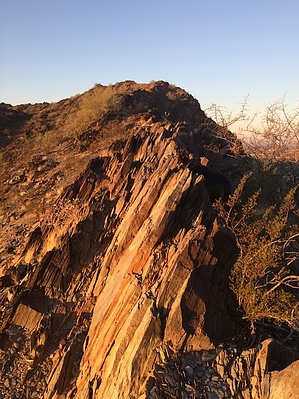
Inner City Gem by airy  If you're looking for solitude and something challenging right in the middle of town, then this is it. Just off of North Cave Creek Road and at the end of East Cortez Street, the hike begins on the road going up to the water tank. If you're looking for solitude and something challenging right in the middle of town, then this is it. Just off of North Cave Creek Road and at the end of East Cortez Street, the hike begins on the road going up to the water tank.Very soon you're off the road onto a well-traveled trail reaching the first saddle only a 1/4 mile in. Stay on the trail and drop down heading south another 1/4 mile to the bottom of the prominent ridgeline. Go off-trail here heading east up to the ridgeline.
Just before you approach Stoney Mountain (the highest peak on the ridgeline), there is a buttress and if approached head-on can be difficult, or it can be skirted to the right to gain the saddle between it and Stoney Mountain. From here the trail heads south along the ridgeline with continued exposure and great views of North Phoenix. At the halfway mark, you drop off of the ridge back down to the valley floor where you skirt a few properties surrounded by a chain-link fence. Now back on established trails, you start cranking back up to the ridgeline. Not near the exposure along this part of the ridgeline and you might even see one or two people, but still relative solitude for the middle of Phoenix. Check out the Official Route and Triplogs. Note This is a moderately difficult hike. Leave No Trace and +Add a Triplog after your hike to support this local community. One-Way Notice This hike is listed as One-Way. When hiking several trails on a single "hike", log it with a generic name that describes the hike. Then link the trails traveled, check out the example. | |||||||||||||||||||||||||||||||||||||||||||||||||||||||||||||||||||||||||||||||||||||||||||||||||||||||||||||||||||||||||||||||||||||||||||||||||||||||||||||||||||||||||||||||||||||||||||


