Overview
Shaw Butte is a fabulous tour of North Mountain Preserve while climbing both Shaw Butte and North Mountain. The entire hike is on established trails (or roads) with easy route finding. It's somewhat strenuous with over 2000 accumulated elevation gain, but you'll be rewarded with endless panoramic views of Phoenix.
Hike
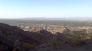
The hike starts where 7th Avenue dead-ends just north of Peoria. Less than a half-mile in, you start cranking up the south side of Shaw Butte. About halfway up and at the 1-mile mark, you get a reprieve from the climbing as you traverse around the west side of the mountain. At the end of the traverse, turn right onto a paved road and start the last 300-foot elevation gain to the top. Only 50 to 100 feet up the road, watch for the trail leading off to the right, which takes you to the summit of Shaw Butte at 1.5 miles into the hike.
From here, you can see the next objective (North Mountain) by looking to the southeast with Piestewa Peak in the background. Now it's 1.5 miles back to the valley floor and a pleasant 1-mile hike over to the Northside of North Mountain. Climbing to the top of North Mountain is via a paved road and the most popular portion of the hike. Once you reach the top of North Mountain, it's a steep descent down the west ridge, by far less traveled than any other part of the hike.
WARNING! Hiking and outdoor related sports can be dangerous. Be responsible and prepare for the trip. Study the area you are entering and plan accordingly. Dress for the current and unexpected weather changes. Take plenty of water. Never go alone. Make an itinerary with your plan(s), route(s), destination(s) and expected return time. Give your itinerary to trusted family and/or friends.
Permit $$
None
Directions
Road
Paved - Car Okay
To hike From downtown Phoenix, AZ
Head west on W Washington St toward N 1st Ave
Turn right onto N 7th Ave
Destination will be on right in 9.4 mi
11000 N 7th Ave
Phoenix, AZ 85029
 Route Editor

 Overview