 Route Editor

| Guide | ♦ | 17 Triplogs | 0 Topics |
details | drive | no permit | forecast | route |
stats |
photos | triplogs | topics | location |
| 225 | 17 | 0 |
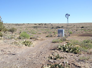
Valley Views by MEWhiteman   Overview OverviewThe Black Canyon Trail (BCT) is recognized as a National Recreational Trail and, when complete, will meander 78 miles from Carefree Highway (AZ74) north to about 8 miles north of Mayer. There are several hike descriptions on this website covering various segments of this trail. This description covers the trail from Antelope Hill on FR259, about 1.1 miles south of Cordes north to where the trail crosses Antelope Creek Road near the town of Spring Valley. The hike is partially along dirt roads and partially along a single track and maintains an elevation between 3,900 to 4,200 feet. There are distant views in many directions as you hike north, and midway through the hike is a nice valley along the single track. The vegetation is mostly low growing shrubs, grasses, and cactus with occasional junipers to provide a little shade during a morning hike. I saw numerous cattle and one jackrabbit along the way. Hike From the parking hike .2 miles east on FR259 toward Cordes until you come to where the trail crosses the road at N34 17.623 W112 10.452. Turn left onto the signed trail heading north on a dirt road. This point is 0.00 miles for the purposes of this description. At 0.34 miles (N34 17.694 W112 10.784), you pass a corral on the left. There are views to the west here, including a distant valley and Crown King behind the valley. At 1.17 miles (N34 18.256 W112 11.124), pass under some powerlines. I saw some cattle in this area, but they are free to roam over much of this area and may be spotted anywhere. At 1.73 (N34 18.651 W112 11.272), pass through a gate. At 1.97 miles (N34 18.822 W112 11.292), there is an old windmill, water tank, and corrals. There was also a dry dirt tank and one steel tank with water. At 2.01 miles (N34 18.856 W112 11.300) just north of the windmill area, turn left to leave the dirt road and begin following a narrow single track. There is a BCT sign here. There are occasional large cairns along this section. At 3.12 miles, the trail turns right to begin descending through a nice valley. At 3.87 miles (N34 19.838 W112 11.351), the trail crosses a drainage and is well marked with cairns. At .04 miles further (N34 19.863 W112 11.366), cross another drainage and turn right following the large cairns to stay on the trail. At about 4.0 miles, stay on the trail with the cairns as there seem to be other cattle trails in this area. At 4.47 miles (N34 20.250 W112 11.370), turn left onto a dirt road. At 4.68 miles (N34 20.397 W112 11.492), turn right onto another dirt road passing under some powerlines. Shortly after topping a small hill, you'll see the objective for this hike, Antelope Creek Road. At 4.80 miles (N34 20.491 W112 11.449), pass through another gate. At 5.08 miles (N34 20.517 W112 11.238), reach Antelope Creek Road. The trail continues north on the other side of the road. There is parking here if you want to spot a car and do this as a one-way hike.
Gate Policy: If a gate is closed upon arrival, leave it closed after you go through. If it is open, leave it open. Leaving a closed gate open may put cattle in danger. Closing an open gate may cut them off from water. Please be respectful, leave gates as found. The exception is signage on the gate directing you otherwise. Check out the Official Route and Triplogs. Leave No Trace and +Add a Triplog after your hike to support this local community. One-Way Notice This hike is listed as One-Way. When hiking several trails on a single "hike", log it with a generic name that describes the hike. Then link the trails traveled, check out the example. | |||||||||||||||||||||||||||||||||||||||||||||||||||||||||||||||||||||||||||||||||||||||||||||||||||||||||||||||||||||||||||||||||||||||||||||||||||||||||||||||||||||||||||||||||||||||


