 Route Editor

| Guide | ♦ | 19 Triplogs | 0 Topics |
details | drive | no permit | forecast | route |
stats |
photos | triplogs | topics | location |
| 211 | 19 | 0 |
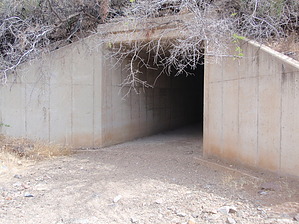
Nearing the End by MEWhiteman   Overview OverviewThe Black Canyon Trail (BCT) is recognized as a National Recreational Trail and when complete, will meander 78 miles from Carefree Highway (AZ74) north to about 8 miles north of Mayer. There are several hike descriptions on HAZ covering various segments of this trail. This description covers the trail from Antelope Creek Road near Spring Valley north to where the trail crosses Old Sycamore Road north of SR69. The hike is a single track and maintains an elevation between 4,000 to 4,200 feet. It is rolling terrain with the trail following the contours of these hills making for easy hiking. The town of Spring Valley is near and visible for much of the hike as is SR69 as you approach and leave it. The vegetation is mostly grasses, low shrubs, prickly pear cactus, and juniper. It's a pleasant hike - pretty easy, not long, cooler than Phoenix. Hike At 0.00 miles (N34 20.517 W112 11.238) begin the hike at Antelope Creek Road heading roughly north. There is a sign at the road and some cairns further in. At 0.77 miles (N34 20.934 W112 10.951) cross under double power lines and over a dirt service road (just a two-track). At 0.90 miles (N34 21.012 W112 10.855) go through a big green gate after crossing the gas pipeline and a wash. Notice the large cairn with bones scattered about just before the gate. At 1.13 miles you begin to get distant views of the town of Spring Valley to the SE. At 1.57 miles past a pile of rocks with a cross on the N side of the trail. I wonder what happened here? At 1.61 miles enjoy a view of Spring Valley and SR69. At 2.39 miles get a distant view of the rectangular tunnel under SR69 which is where the trail crosses. Look hard if you don't see it right away as it is partially hidden. At 2.45 miles begin paralleling a fence. At 2.53 miles (N34 21.709 W112 10.541) turn right to follow the wash just past the end of the fence. There were no signs or cairns here at the time I did this hike.
At 2.65 miles (N34 21.732 W112 10.470) enter a rectangular tunnel under SR69. It is 7 to 8 feet high and about as wide with room for the sheep that used to go through here. There are many bird nests along the junction of the walls and ceiling. You're GPS will lose signal here but should reacquire it at the other end. Continue in the wash after exiting the tunnel. At 2.76 miles (N34 21.792 W112 10.461) pass through a gate. At 3.39 miles (N34 22.210 W112 10.347) this segment ends at Old Sycamore Road. I did not see any signs or cairns at this point when I did the hike. The trail appears to cross and continue north but gets faint shortly after passing through another gate. There is parking about 0.16 miles SE on Old Sycamore Road (up the hill) where another dirt road goes right. There is a pull-off just after turning onto this other dirt road. Gate Policy: If a gate is closed upon arrival, leave it closed after you go through. If it is open, leave it open. Leaving a closed gate open may put cattle in danger. Closing an open gate may cut them off from water. Please be respectful, leave gates as found. The exception is signage on the gate directing you otherwise. Check out the Official Route and Triplogs. Leave No Trace and +Add a Triplog after your hike to support this local community. One-Way Notice This hike is listed as One-Way. When hiking several trails on a single "hike", log it with a generic name that describes the hike. Then link the trails traveled, check out the example. | |||||||||||||||||||||||||||||||||||||||||||||||||||||||||||||||||||||||||||||||||||||||||||||||||||||||||||||||||||||||||||||||||||||||||||||||||||||||||||||||||||||||||||||||||||||||||


