 Route Editor

| Guide | ♦ | 1 Triplog | 0 Topics |
details | drive | no permit | forecast | map |
stats |
photos | triplog | topics | location |
| 7 | 1 | 0 |
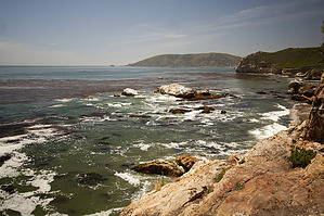
The adventure begins from a large dirt parking area at the end of Cave Landing Road just outside Avila Beach. There are beautiful ocean views from the trailhead, and things only improve out on the trail. Pick up the southbound single track on the left side of the rocky point jutting into the Pacific. Coastal scrub lines the trail, leaving ample headroom for stunning views down the coast toward Shell Beach and Pismo Beach. After a short distance, there comes to a T-junction marked by a unique punched-out metal sign. To the left, a trail descends to Pirate's Cove, where you may see naked bathers enjoying this clothing-optional beach. Only hit the sands if you are prepared to walk the plank (or walk the walk).
Graffiti and broken glass mar the beauty of this short hiking retreat. In addition to nudists, this is also a popular casting off point for local fisherman. After taking in the cave, return the way you came for a memorable fifteen-minute hike. Nearby trails allow further exploration. There is a single track traveling down the top of the headland above the cave, and other paths venturing west across the bluffs toward Avila Beach. Shell Beach Bluff Trail heads east around Pirate's Cove along a mansion-lined road to Shell Beach. Behind that is Ontario Ridge Trail, which explores the 700-foot ridge that rises over Cave Landing. These trails may be hiked as a loop. No fee or permit is required to visit Pirate's Cave, so get out and enjoy. To get to the trailhead: From the 101 Freeway seven miles south of San Luis Obispo, exit on Avila Beach Drive and head west for two miles toward Avila Beach. A mile before the beach town, turn left up Cave Landing Road. Drive half a mile to the end of the road and pull into the large dirt parking area on the left. Check out the Triplog. Leave No Trace and +Add a Triplog after your hike to support this local community. One-Way Notice This hike is listed as One-Way. When hiking several trails on a single "hike", log it with a generic name that describes the hike. Then link the trails traveled, check out the example. | |||||||||||||||||||||||||||||||||||||||||||||||||||||||


