Named for the natural patch of wild rye, this place was first known to be visited by modern man about 1829 on an outing sponsored by the Hudson Bay Company. In 1850 this became the location of a cutoff trail from the California Trail. Known as the Applegate Lassen Trail this led across the Black Rock Desert and on to Goose Lake in northern California and the California gold fields. The Rye Patch settlement soon discovered gold of its own and about one million dollars in gold and silver was produced here between 1864 and 1877.
In the 1930's the Rye Patch Dam was constructed. It is a 75 foot earthen dam creating a 22 mile long reservoir for irrigation purposes. The dam captures water from the Humboldt river which is fed by snow melt from Nevada's Ruby mountains. During construction Archeologists located skeletons from prehistoric camels, bison, elephants and horses who came here to drink.
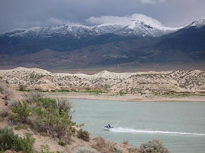
The park is run by the Nevada State Park system and our hike begins just north of the dam. While the reservoir has 72 miles of shoreline most of it is primitive and has unstable cliffs. There is often a lot of boating and swimming activity. The hike meanders in and about the cliffs along the lakefront and has several viewpoints with benches. The often snow covered Humboldt mountains lie just to the south and offer a scenic backdrop to the lake. The cliff sides erode quite easily and staying on the trail is encouraged. Use of wooden stairs and a foot bridge enable compliance. The trail ends at the area campground and returning the way you came results in a one mile hike. There is a $4.00 day use fee and the area has tables, facilities, and water. Fishing is also popular as anglers try for the wiper, a cross between the white bass and striper.
When hiking several trails on a single "hike", log it with a generic name that describes the hike. Then link the trails traveled, check out the example.
WARNING! Hiking and outdoor related sports can be dangerous. Be responsible and prepare for the trip. Study the area you are entering and plan accordingly. Dress for the current and unexpected weather changes. Take plenty of water. Never go alone. Make an itinerary with your plan(s), route(s), destination(s) and expected return time. Give your itinerary to trusted family and/or friends.
Permit $$
Information is listed below
Directions
Road
FR / Dirt Road / Gravel - Car Okay
To hike From east or west I 80 exit 129, Nevada State Route 401 North 2.5 miles to entrance station. There is a four dollar day use fee.
 Route Editor


