Route Editor

| Guide | ♦ | 25 Triplogs | 1 Topic |
details | drive | no permit | forecast | 🔥 route |
stats |
photos | triplogs | topic | location |
| 180 | 25 | 1 |
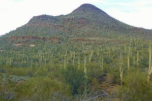
Who's Your Apache Daddy? by AZWanderingBear  Overview OverviewIf you look north while driving along Carefree Highway between I-17 and Cave Creek you will notice three conical peaks, the westernmost being the tallest, the middle a bit shorter and the easternmost the lower of the three. These are known as the Three Apaches, or to locals as Daddy Apache, Mommy Apache, and Baby Apache. This hike takes you to the summit of the Daddy Apache. Warning The trail is steep in places. There is a lot of loose rock along the steeper portions. No water at trailhead or along the route. Lots of chollas out here, too. Be careful.
The Spear S Trailhead is named for a local ranch. Parking is somewhat limited and there are no facilities. A gate on the northeast corner of the trailhead begins the trail. The first two miles of the route are along the Maricopa Trail. This section is well maintained and fairly well signed. A steady climb brings you to the saddle between Hill 2875 to the south and Apache Peak to the north. The saddle is a clear area and you will have some nice views east. As you descend from the saddle, the trail soon takes an abrupt left turn. Start looking for a sign on your left for the faint trail north towards the Apache Peak. The turn is almost exactly 2 miles into the hike. This faint trail meanders upward. Having the GPS route is comforting here (and will be even more useful later). The trail will parallel a drainage on your left for a while and then abruptly turn east before again turning north and topping out just below Mommy Apache. A short hike westward brings you to a split in the trail. You will take the western (left fork) to head up towards the summit. Good time for a breather and a look around. the view up top will be better, but it ain't bad from here. The trail up the side of Apache Peak meanders a bit but is fairly obvious until you get close to the top. All the rock is volcanic basalt. The trail gets steeper with more loose rock as you near the top. It also gets harder to follow. Look up. You are working towards the notch in the cap rock that angles left to right above you. CAUTION: About 20 feet from the top there was an active beehive in the boulders along the south side of the trail. Note where you top out because it isn't obvious when you are ready to come down. The views from the top are worth the effort. Take some time to enjoy. Someone hauled a mailbox up here which houses the summit register, but doesn't get regular mail service. Gate Policy: If a gate is closed upon arrival, leave it closed after you go through. If it is open, leave it open. Leaving a closed gate open may put cattle in danger. Closing an open gate may cut them off from water. Please be respectful, leave gates as found. The exception is signage on the gate directing you otherwise. Check out the Official Route and Triplogs. Leave No Trace and +Add a Triplog after your hike to support this local community. | ||||||||||||||||||||||||||||||||||||||||||||||||||||||||||||||||||||||||||||||||||||||||||||||||||||||||||||||||||||||||||||||||||||||||||||||||||||||||||||||||||||||||||||||||||||||||||||||