username
X
password
register
for free!
help


Deer Creek Narrows, AZ

Guide 17 Triplogs  0 Topics
  4.9 of 5  
Fav
Wish
5
details
drive
permit
forecast
route  
stats
photos
triplogs
topics
location
109 17 0
Statistics
tap row or icons for details
Difficulty 2 of 5
Distance Round Trip 0.55 miles
Trailhead Elevation 2,306 feet
Elevation Gain -344 feet
Accumulated Gain 11 feet
Kokopelli Seeds 0.61
 Interest Off-Trail Hiking, Perennial Waterfall & Perennial Creek
 Dogs not allowed
feature photo
Photos Viewed All MineFollowing
Inaugural Calculation on Button Tap!
61  2022-10-19
Thunder River & Deer Creek Loop
ddgrunning
90  2021-10-27
Deer Creek - Kanab Creek Loop
chumley
20  2016-10-12
Bill Hall Trail
FOTG
22  2014-10-16
Deer Creek / Thunder River
Tough_Boots
44  2014-10-16
Deer Creek / Thunder River
chumley
53  2014-10-16
Deer Creek / Thunder River
BiFrost
30  2014-10-16
Deer Creek / Thunder River
John9L
59  2013-11-02
Deer Creek/Thunder River Loop
Dave1
Page 1,  2
Author
author avatar Guides 16,843
Routes 17,472
Photos 24
Trips 1 map ( 6 miles )
Age 28 Male Gender
Location HAZ, TrailDEX
Associated Areas
list map done
Northwest Region
Historical Weather
Trailhead Forecast
Radar Map
Expand Map
Preferred May, Jun, Oct, Nov
Sun  6:04am - 6:54pm
Official Route & 1 Rt
 
4 Alternative


June 2012
Climbing or rappelling in the creek narrows, with or without the use of ropes or other technical equipment, is prohibited. This restriction extends within the creek beginning at the southeast end of the rock ledges, known as the “Patio,” to the base of Deer Creek Falls. This restriction is necessary for the protection of significant cultural resources.


The hiking trail from the river to hiker campsites and points up-canyon is open.
remove free decal offer
Overview
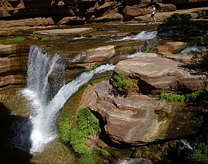
AmAZingly sweet narrows down along the Colorado River with four rappels, some down climbing, loads of wading, and topped off with a final 180ft waterfall rappel

2018-07-14 HAZ_Hikebot
  • Grand Canyon Use Area Boundaries - Dynamic Map


Check out the Official Route and Triplogs.
Leave No Trace and +Add a Triplog after your hike to support this local community.
WARNING! Hiking and outdoor related sports can be dangerous. Be responsible and prepare for the trip. Study the area you are entering and plan accordingly. Dress for the current and unexpected weather changes. Take plenty of water. Never go alone. Make an itinerary with your plan(s), route(s), destination(s) and expected return time. Give your itinerary to trusted family and/or friends.

 Permit $$
NPS

Grand Canyon National Park
Details for each are occasionaly below numerous alerts
Entrance Fee
Overnight/Backpacking Permits
Grand Canyon Use Areas Map
Rim-to-Rim and Extended Day Hike/Run


 Directions
or
 Road
FR / Dirt Road / Gravel - Car Okay

To hike
Access the narrows either by raft or by hiking in from the Bill Hall or Thunder River THs
page created by Vaporman on Jun 11 2011 3:55 pm
 90+° 8am - 6pm kills
helpcorrectionissue

end of page marker