username
X
password
register
for free!
help


Clover Canyon - Sierra Ancha, AZ

Guide 2 Triplogs  0 Topics
  4 of 5  
Fav
Wish
0
details
drive
no permit
forecast
map
stats
photos
triplogs
topics
location
44 2 0
Canyons are inherently risky. Flash floods occur without notice on sunny days. Technical skills & surrounding topography knowledge required yet does not eliminate risk.
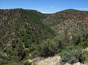
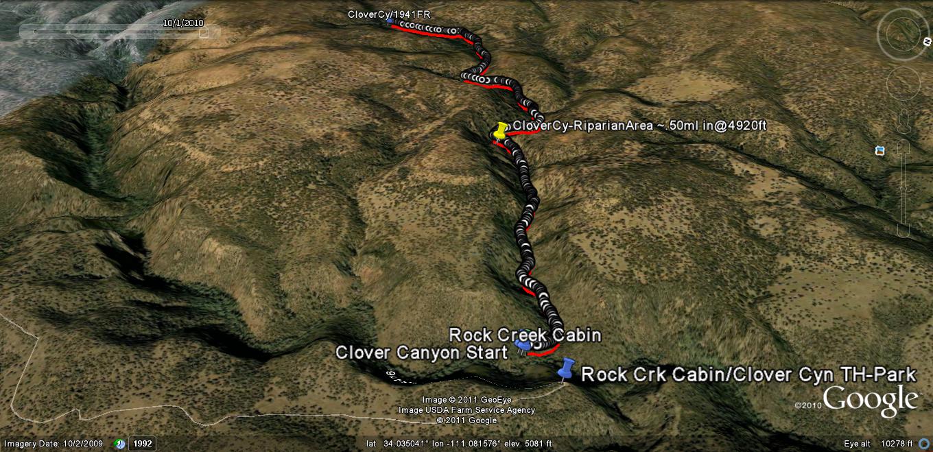
Canyoneering
Consensus
View 1
Grade1
WaterA
Risk
Time
Statistics
tap row or icons for details
Distance Round Trip 2.8 miles
Trailhead Elevation 4,942 feet
Elevation Gain -450 feet
Accumulated Gain 992 feet
Kokopelli Seeds 7.76
 Interest Off-Trail Hiking, Historic, Seasonal Waterfall & Perennial Creek
unreported if dogs are allowed
editedit > ops > dogs to adjust
feature photo
Photos Viewed All MineFollowing
39  2011-07-02 Grasshopper
3  2011-07-02 ssk44
2  2011-06-23 Grasshopper
Author
author avatar Guides 16,843
Routes 17,472
Photos 24
Trips 1 map ( 6 miles )
Age 28 Male Gender
Location HAZ, TrailDEX
Historical Weather
Trailhead Forecast
Expand Map
Preferred Apr, May, Oct, Nov
Sun  6:00am - 6:46pm
1 Route
 
1 Alternative


remove free decal offer

 
Overview
Located adjacent to the "Rock Creek Cabin" hike description and passing by this historic late 19th-century log cabin, this seldom visited, remote, heavy vegetation-riparian canyon with some Class 1 & 2 rock climbing for this hike description's ~.50ml "one-way" distance up canyon could possibly be navigated to its 2.4-mile upper end at its intersection with old abandoned ranching road FR1941.


2018-07-14 HAZ_Hikebot
  • guide related image
    guide related


Check out the Triplogs.
Leave No Trace and +Add a Triplog after your canyon trip to support this local community.
WARNING! Hiking and outdoor related sports can be dangerous. Be responsible and prepare for the trip. Study the area you are entering and plan accordingly. Dress for the current and unexpected weather changes. Take plenty of water. Never go alone. Make an itinerary with your plan(s), route(s), destination(s) and expected return time. Give your itinerary to trusted family and/or friends.

 Permit $$
None


 Directions
or
 Road
Strictly 4x4

To canyon trip
From Phoenix
Hwy 60 to Globe to Hwy 188 to Hwy 288 to the intersection of Hwy 288/FR486;
High Clearance OK when dry on FR486 to the unmarked intersection at FR485 with high clearance 4x4 required from this intersection;
FR485 to end at TH/Park--> N34.03963 W-111.07425; (For your reference and download see posted GPS Track Driving Route "to" TH/Parking "from" Hwy 288/FR486 intersection);
page created by Grasshopper on Jun 23 2011 4:04 pm
 90+° 8am - 6pm kills
helpcorrectionissue

end of page marker