Route Editor

| Guide | ♦ | 1 Triplog | 0 Topics |
details | drive | no permit | forecast | route |
stats |
photos | triplog | topics | location |
| 16 | 1 | 0 |
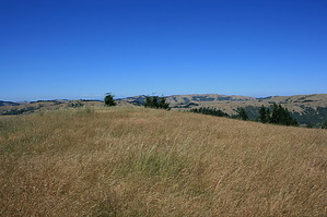
Roof of Marin by JimmyLyding  This next section is pretty gnarly. You're in for an unrelenting climb of over 800 feet over 1.1 mile. This unnamed trail heads up the northeast corner of a ridge running east-west. The northern slopes are covered by a dense forest of second-growth redwoods, and has a majestic forest of Douglas fir on the southern portion. The trail basically follows the spine of the ridge to the top while a fire road runs parallel a few hundred yards to the south. The trail turns right (west) as it crests out on the top of the ridge before reaching the San Geronimo Ridge fire road after hiking 1.5 mile from your car. You've been hiking through the Gary P. Giacomini Open Space Preserve. The rest of the route to Pine Mountain is in the Marin County Watershed.
The San Geronimo Ridge fire road gently ascends a few hundred feet over the next 1.8 miles before a modest descent leads to the junction with the Pine Mountain fire road to the right. You'll pass 2 fire roads that head downhill to the left in this stretch. The Pine Mountain fire road immediately ascends as it heads west towards the summit, but mellows out as you get closer. The fire road never reaches the actual summit so you must take the small trail to the right that heads through dense brush that will probably scratch you. The summit has a nice flat rock amidst some low manzanita. The views are spectacular, and Kent Lake can be viewed from the western edge of the summit. Don't forget to check for ticks! Check out the Official Route and Triplog. Leave No Trace and +Add a Triplog after your hike to support this local community. | ||||||||||||||||||||||||||||||||||||||||||||||||||||||||||||||||||||||||||||||||||||||||