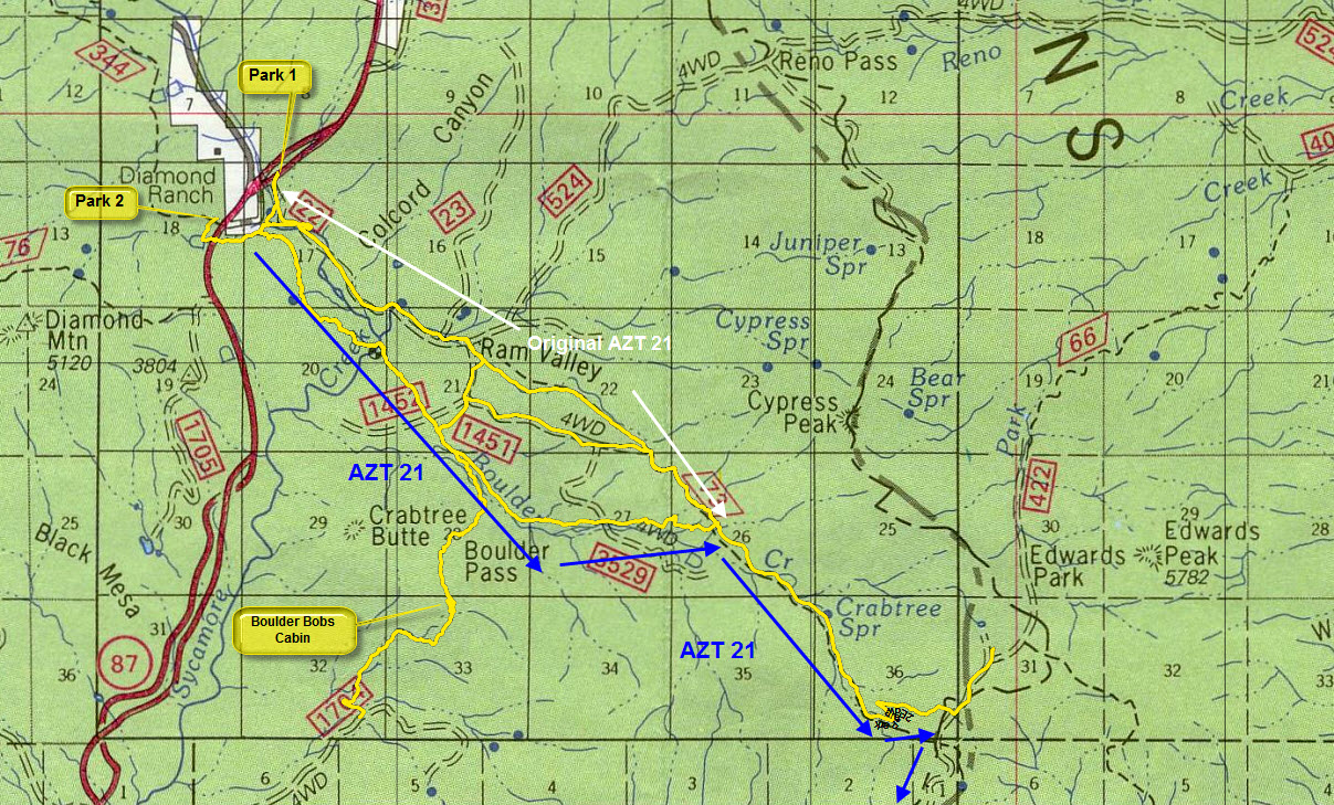
The original plan was to do 14 to 15 miles on the AZ trail. The previous week Grasshopper and I hiked from the Cross F TH to the Boulder creek trail intersection. The sign at the Sunflower / Boulder creek intersection claimed that the FR422 was 7 miles away. I arrived at the Bushnell Tanks exit off of the Beeline. The gate was locked. As I pulled up a game warden was leaving. I asked him when the gate would be opened. He said about a year or two or never. He thought the forest service might open it up on a permit basis. There were about 6 cars and one horse trailer parked by the gate. I started hiking at 8:45 am.
I had to hike down FR22 and took the right spur road at the cattle guard. There's a sign pointing the hikers to the trail. The spur road ends after about 300 feet. Now turn to the south and cross the Sycamore creek and you'll see an AZ Trail plastic sign. The locked gate at the Beeline added .8 miles (one way) to the hike. The boulder canyon trail started with a couple of switchbacks and it leveled off after climbing about 150~200 feet. Now the trail overlooks the Sycamore creek. I came across a tree with two signs 1)To Mexico 385 2)To Utah 423. Now the trail drops down and crosses the Sycamore creek. Watch out for yellow ribbon on the tree branches to help across the creek and pick up the trail again. The trail is more or less flat for a while now. About 3 miles into the hike a came across a boy scout troop building cairns. One of the leader's videos interviewed "a real hiker" and asked how I liked the cairns. As I left the troop one of the boys yelled "you better not get lost now!". About 1/2 mile past the boy scouts I came across the trail stewards on horses. I talked to them for a bit. I asked about the trail and they confirmed it was 7 miles one way it climbed at the end. The stewards told me that the trail was new. The views were pretty neat. The trail was in a valley and it was slowly working its way to the four peaks road FR422.
About a mile after meeting the stewards, the trail disappeared. A bunch of sucker trails appeared and they were more defined than the real trail. I wandered for a couple of minutes before noticing the yellow ribbons on the tree branches. Now it made sense, the stewards were horse riders and they would have used yellow ribbons to follow the trail. Now I had to take it much slower and watch out for yellow ribbons, cairns, and the AZT signs. There was a hill with a bunch of prickle cactus that was tricky until I found a bunch of orange flags in the ground. I was doing OK looking for trail clues until I hit a falling fence line at N33 49.647 W111 24.192. I came down a hill and two fence lines meet forming a right angle. In front of the falling fence line was a cairn and a opening in the fence to the right of it. There was a footpath going into the corral. This mistake cost me about 20 minutes. I looked and looked for a trail and found nothing. I climb up high to see if I could find any clues. I saw an AZT post on the OTHER side of the fence. This baffled me. I climbed down and hopped the fence. On the return trip, I saw what happened. The one fence that was fallen had a gate in it and it occurred the gate. The trail went straight through the gate, NOT TO THE RIGHT! I made a cairn on the fallen fence by the gate. After about 1/2 mile the trail crosses the boulder canyon and slowly rises. Then the trail leaves the boulder canyon and climbs like crazy. By now it's about 1:45 and the sun is hot. By 2:00 I hit FR422. There's a single plastic AZT post showing where trail 73 starts. I walked up and down the road looking for some shade to have lunch. I found some and chilled out for a bit. The GPS shows FR422 as the Mazatzal Divide trail, not FR422. I hiked 10.85 miles by now. I know 0.8 was from the car to the TH and I did wander a bit, but not 3 miles worth. This trail is longer than 7 miles. It has to be 9 miles long. I started back at 2:35. I figured the hike back should be a piece of cake because I figured everything out and I had the GPS log. Wrong! There are a bunch of sucker trails on the way back and I got messed up twice before I figured out what to do. I had to zoom in on the GPS to the 20-foot level and look at my GPS every minute to make sure I was staying on course. This slowed me down a bit. Then I hit the section that the boy scouts cairned and it was like heaven. I could finally hike in 5th gear without worrying about getting off-trail. The scouts did a great job. At 6:15 I pulled out the flashlight. I hit the Boulder Canyon / Sunflower intersection about 6:30. I crossed back over the Sycamore creek to the spur road. Now I get freaked out because there is a fence across the road that was not there in the morning. I walked around it and found another. Next, I saw two people. They are ASU students catching bats and I almost walked into their bat screens. I hit the Jeep at 6:40.
The trail had a lot of pricker bushes on it. My legs look like they went through a cheese grater. If you do this trail, make sure you were long pants and a long sleeve shirt. Full-size gators would help out also. My 15-mile hike turned into a 20.60 mile bushwhack / death march. Once this trail is better marked and cleaned up it will be a great trail.
Gate Policy: If a gate is closed upon arrival, leave it closed after you go through. If it is open, leave it open. Leaving a closed gate open may put cattle in danger. Closing an open gate may cut them off from water. Please be respectful, leave gates as found. The exception is signage on the gate directing you otherwise.
When hiking several trails on a single "hike", log it with a generic name that describes the hike. Then link the trails traveled, check out the example.
WARNING! Hiking and outdoor related sports can be dangerous. Be responsible and prepare for the trip. Study the area you are entering and plan accordingly. Dress for the current and unexpected weather changes. Take plenty of water. Never go alone. Make an itinerary with your plan(s), route(s), destination(s) and expected return time. Give your itinerary to trusted family and/or friends.
Permit $$
None
Directions
Road
Paved - Car Okay
To hike From Phoenix, take the beeline to just past Sunflower and turn on the Bushnell tanks exit. PARK IN FRONT OF THE GATE.
 Route Editor


 The original plan was to do 14 to 15 miles on the AZ trail. The previous week Grasshopper and I hiked from the Cross F TH to the Boulder creek trail intersection. The sign at the Sunflower / Boulder creek intersection claimed that the FR422 was 7 miles away. I arrived at the Bushnell Tanks exit off of the Beeline. The gate was locked. As I pulled up a game warden was leaving. I asked him when the gate would be opened. He said about a year or two or never. He thought the forest service might open it up on a permit basis. There were about 6 cars and one horse trailer parked by the gate. I started hiking at 8:45 am.
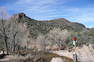


