Route Editor

| Guide | ♦ | 1 Triplog | 0 Topics |
details | drive | permit | forecast | route |
stats |
photos | triplog | topics | location |
| 13 | 1 | 0 |
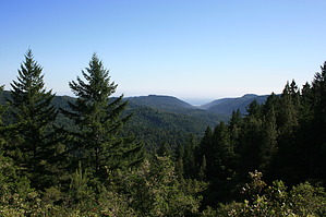
Easy Intro to Big Basin by JimmyLyding  I've set the beginning of this hike as the park headquarters, but you will most assuredly be parking in a spot that isn't in the immediate vicinity. From the HQ walk northwest past the store and snack shop to a small bridge over Opal Creek. Take the signed Skyline To The Sea Trail left. You are already in a dense forest of mixed Douglas fir and redwood. The STTST heads west for 0.4 mile before going north for 0.5 mile to its intersection with the Middle Ridge Road. There's a metal trail map that looks to have been shot, and turn left for 50 yards until the Howard King Trail branches off to the right. You can also continue straight along the Middle Ridge fire road, and then turn right onto the Hinn Hammond fire road. Both Hinn Hammond and Howard King end up at McAbee Mountain, but Howard King is a little more interesting because it's a small trail while Hinn Hammond is a wide fire road. Both routes branch away from each other only to join for brief stretches between STTST and McAbee Mountain.
You can return the way you came or enjoy one of the many alternates to the route I took. The Howard King Trail continues north from McAbee Mountain 2.0 miles down to Berry Creek Falls. From Berry Creek Falls head east along the STTST back to the park HQ. Check out the Official Route and Triplog. Leave No Trace and +Add a Triplog after your hike to support this local community. | |||||||||||||||||||||||||||||||||||||||||||||||||||||||||||||||||||||||||||||||||||||