Route Editor

| Guide | ♦ | 6 Triplogs | 0 Topics |
details | drive | permit | forecast | route |
stats |
photos | triplogs | topics | location |
| 50 | 6 | 0 |
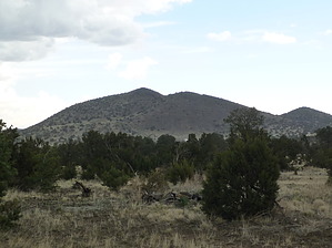
Great Place to Explore by squatpuke   O'Neill Crater (cinder cone) is part of the San Francisco Volcanic Field which covers roughly 4700 square kilometers of Northern Arizona and contains many, many volcanic features including mountains, domes, and cinder cones. Famous points of interest in the field include Sunset Crater, Mt. Elden, and of course, the San Francisco Peaks. O'Neill Crater (cinder cone) is part of the San Francisco Volcanic Field which covers roughly 4700 square kilometers of Northern Arizona and contains many, many volcanic features including mountains, domes, and cinder cones. Famous points of interest in the field include Sunset Crater, Mt. Elden, and of course, the San Francisco Peaks.However, there are a wide variety of small domes and cinder cones in Northern Arizona, all of which are worthy of hiking and exploring (where legal). Nestled outside of a neighborhood in Doney Park, within the Coconino National Forest lies a sweet little cinder cone with lots to explore called O'Neill Crater.
At the highpoint on the northern peak, there are 2 easy to find benchmarks. Potsherds abound in this area, please follow the proper etiquette when exploring and take NOTHING but photographs.. :) Check out the Official Route and Triplogs. Leave No Trace and +Add a Triplog after your hike to support this local community. | |||||||||||||||||||||||||||||||||||||||||||||||||||||||||||||||||||||||||||||||||||||||||||||||