|
tap row or icons for details
|
| Difficulty |
|
2 of 5 |
| Distance One Way |
|
7 miles |
| Trailhead Elevation |
|
2,970 feet |
| Elevation Gain |
|
1,422 feet |
| Avg Time One Way |
|
3.5 hours |
| Kokopelli Seeds |
|
11.74 |
| Backpack No | |
| | |
|
|
27 |
2022-03-31 |
Black Mountain Matters |
DixieFlyer |
|
|
|
13 |
2012-09-26 | LittleKnee |
|
| |
|
|
|
list |
map |
done |
Vegas Region |
| | |
|
| |
|
|
Historical Weather |
| Trailhead Forecast | | |
|
 |
|
|
| Preferred Mar, Nov, Apr, Oct |
| |
|
|
| | |
| |
Named Locations Coordinate Links
| |
|
| help future hikers |
| post a gps route now |
|
Black Mountain Matters
|
7.56 mi
2,120 ft |
 |
| | |
| |
|
|
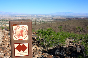
Snake up and down the McCullough foothills by autumnstars   This hiking and biking trail follows a combination of built trail and utility roads in the foothills of the McCullough Range. Anthem East Trail has a trail head at each end, one at Shadow Canyon Road and the other at the Anthem Hills Park. The trail is maintained by the city of Henderson, so it is very easy to follow with frequent signs. Highlights include sweeping views of the Las Vegas valley, easy access, and connections to side trails leading up many of the peaks in the McCullough Range, such as Black and Red Mountains. This is certainly not a remote trail, traveling under several high-tension power lines and behind housing developments. Several series of switchbacks (some quite steep) snake up and down the foothills, resulting in far-reaching views of the entire valley. Not a very adventurous trail, but you can explore up any of the washes and ridges this trail intersects. Overall, the wide and relatively smooth tread plus availability of water at one of the two trail heads makes this an ideal trail for exercise or training. Also good if you live in the area and just need to get out but don't have time to travel far.
Warning: No shade at all! Not a smart hike for the middle of the day in summer. One-Way NoticeThis hike is listed as One-Way. When hiking several trails on a single "hike", log it with a generic name that describes the hike. Then link the trails traveled, check out the example. |
 Route Editor


