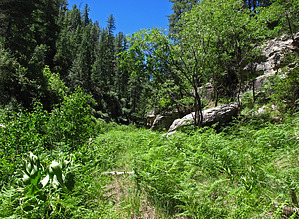
Located within the "Cabin Loop Trails" area on the Mogollon Rim, this remote Class 1 hiking loop area of upper Barbershop Canyon sees few human visitors. It offers some delightful summer off-trail hiking in this riparian canyon section with summer perennial water flows, nice pools, beautiful riparian vegetation, and an opportunity to possibly view various Mogollon Rim wildlife as you navigate the numerous animal trails with some tree downfall to navigate under, around, and over. Also, you should note that the posted GPS default track is highly recommended for download and following as the descent into and climb out of Barbershop Canyon requires some intermediate navigation skills.
WARNING! Hiking and outdoor related sports can be dangerous. Be responsible and prepare for the trip. Study the area you are entering and plan accordingly. Dress for the current and unexpected weather changes. Take plenty of water. Never go alone. Make an itinerary with your plan(s), route(s), destination(s) and expected return time. Give your itinerary to trusted family and/or friends.
Permit $$
None
Directions
Road
High Clearance possible when dry
To hike From the PHOENIX area: Take the Beeline Hwy 87 north all the way past Payson, Strawberry, and past the small community of Clints Well; Continue on Hwy 87 past the right turn for signed Blue Ridge Reservoir, continue on Hwy 87 past the signed right turn for Moqui / Blue Ridge Campgrounds, continue on Hwy 87 past the Blue Ridge Ranger Station to the next signed FR right turn onto FR95; Turn Right onto FR95 at way point N34 36.785 W111 11.209 and follow signs for FR95 South, then a major downhill on FR95 to FR95/FR96 intersection after crossing East Clear Creek Bridge; "Stay on" FR95 (a ~right turn SSW) and continue uphill until you reach signed FR139; Turn left onto FR139 (Note: set your odometer to "0") and continue south on FR139 for ~6.6mls to signed FR139C on your left side at waypoint N34 26.535 W111 11.900; Turn Left onto unmaintained, easy to follow gravel FR139C (Note: set your odometer to "0") and continue driving on FR139C for 2.10 miles to primitive campsite entrance/TH Start, a right turn at waypoint N34 27.546 W111 10.598;
Please also note: Via either Hwy 260 east/FR300 from Payson "or" Hwy 87 north/FR300 (at Milepost 281.1 on Hwy 87), you can drive to the SW end of FR139 at its intersection with Rim Road FR300, then drive north up FR139 for ~2.0 miles to intersect FR139C and then make a right turn onto FR139C and follow the directions noted above;
page created by Grasshopper on Jul 20 2011 10:32 am
 Route Editor

 Located within the "Cabin Loop Trails" area on the Mogollon Rim, this remote Class 1 hiking loop area of upper Barbershop Canyon sees few human visitors. It offers some delightful summer off-trail hiking in this riparian canyon section with summer perennial water flows, nice pools, beautiful riparian vegetation, and an opportunity to possibly view various Mogollon Rim wildlife as you navigate the numerous animal trails with some tree downfall to navigate under, around, and over. Also, you should note that the posted GPS default track is highly recommended for download and following as the descent into and climb out of Barbershop Canyon requires some intermediate navigation skills.