Route Editor

| Guide | ♦ | 2 Triplogs | 0 Topics |
details | drive | no permit | forecast | route |
stats |
photos | triplogs | topics | location |
| 12 | 2 | 0 |
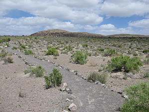
American Graffiti by AZLOT69  Hike: The hike starts from a fully improved BLM trailhead equipped with a restroom and placards along with a table. Once, and not so long ago, this area was heavily looted and used as a firing range. I even saw huge basalt boulders with petroglyphs from this site along Maine street in Fallon, Nevada, 10 miles away. The BLM has secured the area now and the trail allows you to explore the remaining petroglyphs. The trail meanders around the hillside making up two complete loops. You end up on top of the mountain where the vistas seem never ending. To the north lies Black Rock desert and to east Sand Mountain and 40 mile desert. The past clashes with the present as the silence is broken occasionally and regularly as jet fighters from nearby Fallon Naval Base perform touch and go exercises. Check out the Official Route and Triplogs. Leave No Trace and +Add a Triplog after your hike to support this local community. | ||||||||||||||||||||||||||||||||||||||||||||||||||||||||||||||||||||||||||||||||||