Route Editor

| Guide | ♦ | 3 Triplogs | 0 Topics |
details | drive | permit | forecast | 🔥 route |
stats |
photos | triplogs | topics | location |
| 24 | 3 | 0 |
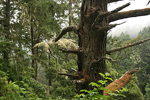
Hike a Mountain in the Clouds by the Sea by JimmyLyding  The coastal Miwok Indians made Point Reyes their home for millenia before Englishman Sir Francis Drake became the first European to visit California in 1579. It was pretty much downhill from there for the Miwok people. Spaniard Sebastian Vizcaino spotted the headlands around Point Reyes (across Drake's Bay to the west from Mount Wittenberg) on January 6, 1603 which is the Feast of the Epiphany. He named the point "La Punta de Los Tres Reyes" in honor of the Three Wise Men. Europeans were sporadic visitors to Point Reyes until Franciscan missionaries arrived 172 years later in 1775. The Miwok suffered from new diseases, cultural assimilation, and the destruction of their way of life until 80% of them were gone by the time California became a state in 1850. Dairy farms soon took over the area due to its proximity to San Francisco, ample water supply, and the abundant forage made possible by the Miwok's use of fire to clear out numerous small areas.
The Mount Wittenberg Trail gently ascends 1,300 feet as it heads west from the Bear Valley Trail to the forested summit. The trail travels through deep forests of huge Douglas fir and California bay, but there is a lot of grass drooping over the trail so make sure to check for ticks. Poison oak is also a constant worry on this hike. You pass through a few open areas as well, and the contrast between tall golden grass and dark green forest is striking in midsummer. You reach a 4-way junction 2 miles up from Bear Valley, and take the well-signed turn to the right up to the summit. This junction is located in an open area surrounded by deep forest, and had fast-moving fog rolling through it today (July 30, 2011). This is a common occurrence during summer months. Winter is either clear or raining, but always muddy. It was a little muddy today, but nothing serious. The summit of Mount Wittenberg is reached by a little 0.4 mile lasso loop from the 4-way junction, and is nothing more than a flat spot with trees everywhere. There are few views if it's clear, and no view if it's foggy like it was today. There is a summit marker, however. Follow the lasso loop back to the junction, and turn right/north onto the Ranch Trail to leave the open area into a gloomy forest. You travel about 1/3 mile through a dense stand of bishop pine that is especially dark on a cloudy day. The bishop pines here have formed a dark forest here courtesy of a thick overhead canopy filled with numerous small and seemingly dead trees. The only things on the ground are pine needles and the occasional mushroom. You reach a 3-way junction 0.7 mile from the previous junction, and turn left/west onto the Fire Lane Trail to travel high above Haggerty Gulch. This stretch had the best views during today's cloudy/foggy hike. Go left/south onto the Sky Trail to reach the Sky backcountry campground. There's water here, and a small backcountry campground featuring picnic tables and vault toilets. This hike would be a great beginner backpacking trip courtesy of Sky camp. Continue south along the Sky Trail for 0.6 mile to a 4-way junction. Head left/north back to the 4-way junction just below Mount Wittenberg, or go down the Meadow Trail for a 1.6 mile trek to the Bear Valley Trail. The Meadow Trail starts out mellow while heading through very tall Douglas firs then an open area that is slowly being reclaimed by the forest. The Meadow Trail then begins a steep descent through a thick oak and bay forest. The trail has pretty much been a dream to this point, but this stretch has a lot of roots in the trail, and is steep in places. You finally reach the Bear Valley Trail where turning left will take you back to the visitor center 0.8 mile away. Gate Policy: If a gate is closed upon arrival, leave it closed after you go through. If it is open, leave it open. Leaving a closed gate open may put cattle in danger. Closing an open gate may cut them off from water. Please be respectful, leave gates as found. The exception is signage on the gate directing you otherwise. Check out the Official Route and Triplogs. Leave No Trace and +Add a Triplog after your hike to support this local community. | |||||||||||||||||||||||||||||||||||||||||||||||||||||||||||||||||||||||||||||||||||||||||||||||||||