Route Editor

| Guide | ♦ | 1 Triplog | 0 Topics |
details | drive | permit | forecast | 🔥 route |
stats |
photos | triplog | topics | location |
| 27 | 1 | 0 |
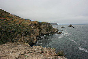
Bear Valley to the Beach by JimmyLyding  This hike begins at the Bear Valley Visitor Center in Point Reyes National Seashore just west of the small B&B town of Olema. Head directly south from the twin parking lots on the Bear Valley Trail, and pass the junction with the Mount Wittenberg Trail after 0.2 mile. The trail here is basically a very smooth dirt road that looks to have its edges mowed out to about 5 feet from the edge. This trail is the only open spot going through a deep and dark forest. Douglas fir, California bay, and coast live oak tower above a dense understory of poison oak, stinging nettle, raspberry, and various ferns. This trail is not the place to get away from the crowds because any hiker is likely to encounter at least a dozen other hikers, but the trail is wide and easy. I saw a few mountain bikers today, but this doesn't seem like good mountain bike country. Most of the trails in Point Reyes that would entice mountain bikers are off-limits to bikes.
Go right onto the Baldy Trail to begin a fairly steady ascent of 700' over 1.1 miles to its junction with the Sky Trail. The Baldy Trail goes through deep forest, but the dense underbrush of Bear Valley and Coast creeks is replaced by tall grass interlaced with poison oak and stinging nettle. I guess now is a good time to mention that it's a good idea to wear pants on this hike. The 2 to 3 foot tall vegetation lining the trail also conceal ticks so make sure to check yourself often. The forest opens up as you reach the highest part of the hike, and turn left onto the Sky Trail heading down to the ocean 860' and 1.5 miles below. Views of Point Resistance and a vast sweep of Pacific Ocean loom in front of you as the Sky Trail heads to the Coast Trail, and the area is frequently foggy and windy. You reach the Coast Trail firmly in the grasp of the soft California coastal chaparral that's primarily characterized by chamise. Go right for 0.5 mile to the stair steps down to Kelham Beach. There's a nice little waterfall right where the stairs meet the beach, and the beach itself is pretty large. It looks to head at least 0.5 mile south, probably longer but I didn't have time to check it out. The beach is backed up by a steep cliff of the granite that underlies most of Point Reyes. Point Reyes used to be next to where Monterey is, but moved northwest to its present location over the last 60 million years, and this granite is key to that understanding. This particular granite is only found around Monterey and Point Reyes, but most of the area is sandstone that's been lifted from the seabed over the eons. The sandy soils in Point Reyes can't support redwood forests even though the climate is perfect for the giant trees. Return the way you came after exploring Kelham Beach, and reach the Bear Creek Trail after continuing 0.5 mile past the Coast Trail / Sky Trail junction on the Coast Trail. Go right 0.2 mile to a promontory over the Pacific at Arch Rock for a panoramic view of the coast. A large rock covered with seabirds looms north with Point Reyes itself in the background to the north, and small islets rest below the cliffs along the coast to the south. Take a lot of pictures, enjoy the scenery and clean ocean air before heading 4.2 miles straight north on the Bear Creek Trail to the parking lot. Check out the Official Route and Triplog. Leave No Trace and +Add a Triplog after your hike to support this local community. | ||||||||||||||||||||||||||||||||||||||||||||||||||||||||||||||||||||||||||||||||||||||||||||||||||||||