username
X
password
register
for free!
help
 This is likely a great time to hike this trail!  Check out "Preferred" months below, keep in mind this is an estimate.
  

Grinnell Lake, MT

Guide 6 Triplogs  0 Topics
  4 of 5  
Fav
Wish
0
details
drive
permit
forecast
map
stats
photos
triplogs
topics
location
81 6 0
Statistics
tap row or icons for details
Difficulty 1 of 5
Route Finding 1 of 5
Distance Round Trip 2 miles
Trailhead Elevation 4,944 feet
Elevation Gain 50 feet
Avg Time Round Trip 1.25 hours
Kokopelli Seeds 2.25
 Backpack No
 Dogs not allowed
feature photo
Photos Viewed All MineFollowing
45  2024-07-06
Grinnell Glacier-High Lake Viewpoint TR
Lucyan
24  2022-06-09
Grinnell Lake Loop
markthurman53
26  2011-07-23 writelots
50  2011-07-23 tibber
44  2010-08-10
Piegan Pass
Vaporman
5  2009-08-17 gummo
Author
author avatar Guides 21
Routes 1,182
Photos 36,858
Trips 1,570 map ( 15,177 miles )
Age 69 Female Gender
Location Phoenix, AZ
Associated Areas
list map done
North Central Region
Historical Weather
Trailhead Forecast
Expand Map
Preferred Jun, Sep, Jul, Aug
Seasons   Summer to Early Autumn
Sun  5:56am - 7:11pm
1 Route
 
1 Alternative


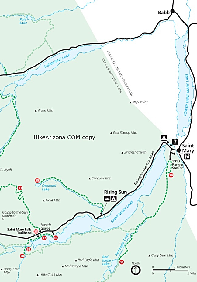
another "gem" of a lake in Glacier Park
by tibber

 Likely In-Season!
Option A for hike description: Take the boat (Morning Star) from the dock in front of the Many Glacier Hotel ($22 RT as of 2011). You will cruise to the other end of Swiftcurrent Lake and then walk up a hill (1/4 mile) to Lake Josephine where another boat (Morning Eagle) waits to take you to the other end. From there, you start your hike to the shore of Grinnell Lake or Lower Grinnell Lake as there is a little lake up by Grinnell Glacier also called Grinnell Lake, or Upper Grinnell Lake.


The trail starts at the boat dock/Oastler Shelter (for inclement weather). You will follow along Cataract Creek in a sub-alpine forest for about 1/2 mile to a one-person suspension bridge over the creek with Hidden Falls to your left. You can only see Hidden Falls from the trail a little before and after the bridge and from the bridge.
remove free decal offer
Hidden Falls is a small water fall a short distance off the main trail to Lake Grinnell. There is a slight uphill section to get to the falls. The falls is tucked away up a small canyon. Because the falls is more or less hidden (thus its name) it is difficult to get a good view of it.

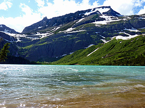
A good portion of the trail from here between Lake Josephine and Lower Grinnell Lake is on raised plank bridges above water runoff from surrounding mountains. You will encounter a trail intersection where you can head up to Feather Plume Falls and/or Piegan Pass.

The trail ends at a small beach on the spectacular Lower Lake Grinnell (George Bird Grinnell was an early explorer and conservationist). This is a crystal clear alpine lake that is fed by melting glaciers. Mount Gould rises high above it. Grinnell Falls (to the west) comes from Upper Lake Grinnell which sits below Salamander and Grinnell Glaciers. They do not fall directly into lower Lake Grinnell. You can't quite see the turqoise look of the water like you can from above so if you've got a mind to, hike one of the best hikes in the park: the Grinnell Glacier Trail.

This is just another of the wonderfully short hikes one can take to a sub-alpine lake in Glacier Park. Oh, and the planks make it interesting and fun.

Option B: You can take this hike from the Many Glacier Hotel which takes you along Swiftcurrent and Josephine Lakes (about 6.5 miles RT as you can hike back a different direction around Josephine Lake). It starts at the Grinnell Glacier TH parking lot. Your hike from here is out in the woods (with a view of Swiftcurrent Lake and Many Glacier hotel as you get to the other end of Swiftcurrent Lake) until the boat dock. You go up the same paved path as the boaters and then go to your left when you reach the boat dock at Lake Josephine. You will hike on a trail through a bit of vegetation and eventually the trail will merge with the Lake Grinnell trail.

And as always, be mindful of bears.

2011-08-11 tibber
  • goat haunt map st mary map mcdonald map
    area related


Check out the Triplogs.
Leave No Trace and +Add a Triplog after your hike to support this local community.
WARNING! Hiking and outdoor related sports can be dangerous. Be responsible and prepare for the trip. Study the area you are entering and plan accordingly. Dress for the current and unexpected weather changes. Take plenty of water. Never go alone. Make an itinerary with your plan(s), route(s), destination(s) and expected return time. Give your itinerary to trusted family and/or friends.

 Permit $$
None

Glacier National Park
$30 per car(week), $12 bike/foot(week), $50 annual View Current Entrance Fees


 Directions
or
 Road
Paved - Car Okay

To hike
From Hiway 2 at Browning, take Hiwy 89 - 35 miles to Babb. From Hiway 2 at East Glacier, come into the Park (north), take Hiwy 49 (Kiowa Loop - scenic but not in the best shape) - 39 miles to Babb which is north past St Mary.

You will be heading for Many Glacier. From Babb, proceed west (toward the mountains) approximately 12.8 miles into Glacier National Park (you will pass the Many Glacier Hotel
page created by tibber on Aug 11 2011 2:55 pm
 90+° 8am - 6pm kills
helpcorrectionissue

end of page marker