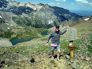
Overview: In July the drive into Yankee Boy Basin and/or hike to Blue Lakes Pass at 13,000ft (or beyond to Blue Lakes) is a solid "five star" adventure and not to be missed if spending a few days in the Ouray, CO area; July wildflowers, waterfalls, perennial creeks, and stellar near and distant views of this section of the Uncompahgre Wilderness high peaks is a must experience;
WARNING! Hiking and outdoor related sports can be dangerous. Be responsible and prepare for the trip. Study the area you are entering and plan accordingly. Dress for the current and unexpected weather changes. Take plenty of water. Never go alone. Make an itinerary with your plan(s), route(s), destination(s) and expected return time. Give your itinerary to trusted family and/or friends.
Permit $$
None
Directions
Road
Strictly 4x4
To hike From Ouray, CO: just south of town on Hwy 550 past first switchback then on uphill climb turn right(west) on signed CO 361 Camp Bird Mine/Yankee Boy Basin Road; Continue on this CO 361maintained high clearance road for ~4.6mls to view of Camp Bird Mine/Tailings on left, veer right and continue for an additional mile or so to another junction "passing" the turn-off on left for Imogene Pass and the old mining/ghost town of Sneffels; You are now in Yankee Boy Basin area; Continue driving straight on CO26 (possibly not signed as such) and quickly becoming a 4WD road from ~1.8mls to the "official" Parking/TH Start for the Blue Lakes Trail; You can also find a parking location just off the shoulder of this CO26 and day hike 4WD CO26 for the ~1.8ml distance to the TH Start.. See posted 7/15/07 GPS Tracks with "key" way points for additional details;
page created by Grasshopper on Aug 22 2011 10:18 pm
 Route Editor