 Route Editor

| Guide | ♦ | 266 Triplogs | 12 Topics |
details | drive | no permit | forecast | 🔥 route |
stats |
photos | triplogs | topics | location |
| 2.6k | 266 | 12 |
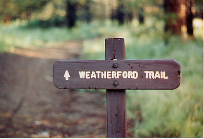
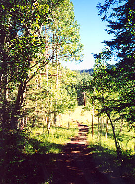
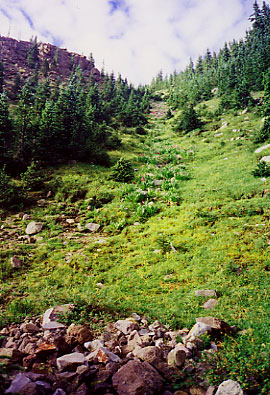
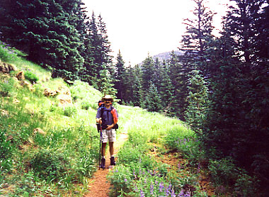
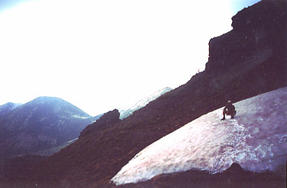
Above tree line alpine experience by nealz  Here's another way to the top of Mt. Humphreys, Arizona's highest mountain at 12,633'. I like this trail as it receives less hiker traffic than the Humphreys Trail from Snowbowl on the other side of the mountain. It is an additional mile one-way from the end of #102 on #151 to the summit. Here's another way to the top of Mt. Humphreys, Arizona's highest mountain at 12,633'. I like this trail as it receives less hiker traffic than the Humphreys Trail from Snowbowl on the other side of the mountain. It is an additional mile one-way from the end of #102 on #151 to the summit.From the trailhead you won't be able to see your final destination, Mt. Humphreys. Instead, you'll be treated to an open Ponderosa Pine forest that quickly climbs into Aspen, and more alpine species like Englemann Spruce, Limber Pine and Bristlecone Pine. Thankfully, there is no evidence of the Leroux Fire, burning earlier this year, visible from anywhere along the Weatherford.
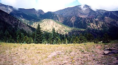
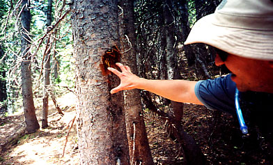
After about 2 miles, the trail enters the Kachina Peaks Wilderness area, and it also starts to make long switchbacks up the bottom of Fremont Peak. During July 2001, there were wildflowers all along the trail to Doyle Saddle, purple-blue lupine, bright red paintbrush, and some yellow daisies, resulting from a good wet winter and spring. Soon enough, you'll reach the 10,800' Doyle Saddle and a stunning view of the Inner Basin and your first sighting of Humphreys Peak beyond. Now, on the USGS Topos, Doyle Saddle is incorrectly named Fremont Saddle, and Fremont is wrongly called Doyle Saddle. The Coconino NF folks at the Peaks Ranger District confirmed the correct nomenclature. As you stand at the saddle, looking at Humphreys, Doyle Peak is the lower mound to your right, and Fremont Peak, the taller one, is on your left. If you choose to make this an overnight backpacking trip, and I hope you do, there is no camping allowed on the Weatherford between Doyle and Fremont Saddles. You can camp just before Doyle Saddle or just past Fremont Saddle. The trail continues, relatively level along the side of Fremont Peak. You will pass several avalanche slides and a great view of the Inner Basin. The trees will form a corridor for you to walk through, and soon you'll be gently climbing up Fremont Peak towards the saddle. As I entered the thicker forest, I spotted a smallish black bear ahead of me. I waited and mentally replayed the what-to-do-when-you-see-a-bear-on-the-trail instructions. The bear evidently had bigger fish to fry and moseyed off into the forest. There were a few wild strawberry plants along the trail, and my guess would be that's what he was after. That night, I discovered claw marks on a tree just outside my campsite. I continued at a quicker pace, all hopped-up on adrenalin. As you reach Fremont Saddle, altitude 11,354', you'll see an old wood stove and other evidence of Weatherford's camp. There is also a relatively recent chunk of helicopter main rotor to be seen with a metal 'Bell Helicopter' tag on it. I've heard two fairly apocryphal stories about this. From the mid-1970s, one explained that a rescue team had been flown up to Fremont Saddle to fly out an injured skier when the main rotor struck a tree, and the chopper went down, killing the pilot. If anybody out there knows anything about this, I'd be interested to hear it. Soon after Fremont Saddle, the trail slowly switchbacks across the east flank of Agassiz Peak, and the forest starts to thin out as you approach tree line. I always like this part of the trip as it makes me feel like a real mountaineer. The views back down the Weatherford serve to remind you just how far you've come. At the edge of the tree line, the only thing resembling trees are the Bristlecone Pines, which at this altitude look like small shrubs. In fact, they are hundreds of years old and are stunted by the extreme climatic conditions here. Now you are above the tree line and have a good view of your final destination, Mt. Humphreys. This trip, there was a patch of snow across the trail just before the saddle to Humphreys. Before going on this trip, I had wondered how wise it was to time this during our monsoon. The day started sunny enough, but the higher I went, the darker it got. Sure enough, at 12,291', the last saddle before the final scramble up some scree to the summit, it started to rain, then hail. Rain and hail don't bother me much, but lightning does, and there was plenty of that too. At this point on the trail, there is absolutely no cover whatsoever. So I reluctantly called it quits and high-tailed it back down to Fremont Saddle only about 500' shy of the summit. Dang! Although I am reminded of the little ditty- "He who hikes, but quits partway, lives to hike another day." Small consolation, but I can tap away at a keyboard without wondering what a near-death lightning strike is like. This is an out-and-back trip, so return down the Weatherford the same way you came up. It will look different going down probably because you'll have the time to see things instead of gasping for breath as you did on the ascent. I'd recommend this trip to anybody who wants to see some of the highest real estate in Arizona. Lightning Kills Stay off the mountain when thunderstorms are forecasted. July and August are notorious for quick unexpected storms. Lower the risk by being OFF the mountain before 11am on a clear morning. Stay safe, read the NOLS Backcountry Lightning Safety Guidelines.
Coconino FS Details The remains of an old road that once took Model T Fords to the top of the San Francisco Peaks provides the route for this winding mountain trail. The road has since been closed to vehicle traffic to protect the area's alpine environment, and the upper reaches of the mountain have been set aside as a Wilderness Area so forest visitors can enjoy its panoramic views in the relative seclusion and natural surroundings such an area provides. Along the steady but gradual climb, views stretch to Oak Creek Canyon and the Verde Valley over fifty miles away. Trailside vegetation changes as elevation increases, from ponderosa pine to more alpine species such as limber pine, corkbark fir, and bristlecone pine. At about 9,000 feet a very noisy black, gray, and white bird makes its first appearance. This is the Clarks nutcracker, a type of jay, which is more commonly thought of as a resident of the Rocky Mountains but finds this part of Arizona very much to its liking. Black bear are sighted periodically as are wild turkey and blue grouse. The Weatherford Trail is an excellent place to hear the bugling of bull elk in the Fall, as they gather their harems for the breeding season. It's also one of the best places on the forest to enjoy the autumn change of leaves among the huge aspen groves in the mountain's inner basin. Come early, though, the leaves change here well ahead of anyplace else on the forest. The Weatherford Trail ends at its intersection with the Humphreys Trail, which then continues on to the top of Mt. Humphreys the highest point in Arizona at 12,643 feet.
Check out the Official Route and Triplogs. Note This is a moderately difficult hike. Leave No Trace and +Add a Triplog after your hike to support this local community. One-Way Notice This hike is listed as One-Way. When hiking several trails on a single "hike", log it with a generic name that describes the hike. Then link the trails traveled, check out the example. | |||||||||||||||||||||||||||||||||||||||||||||||||||||||||||||||||||||||||||||||||||||||||||||||||||||||||||||||||||||||||||||||||||||||||||||||||||||||||||||||||||||||||||||||||||||||||||||||||||||||||||||||||||||||||||


