username
X
password
register
for free!
help
 

Gooseberry Mesa, UT

Guide 7 Triplogs  0 Topics
  5 of 5  
Fav
Wish
1
details
drive
no permit
forecast
map
stats
photos
triplogs
topics
location
4 7 0
Statistics
tap row or icons for details
Distance One Way 6 miles
Trailhead Elevation 5,138 feet
feature photo
Photos Viewed All MineFollowing
10  2023-04-15
Zion 100 Mile Ultramarathon
fricknaley
10  2020-09-29
Gooseberry Mesa Loop
Nightstalker
4  2011-09-17 autumnstars
Author
author avatar Guides 16,843
Routes 17,472
Photos 24
Trips 1 map ( 6 miles )
Age 28 Male Gender
Location HAZ, TrailDEX
Historical Weather
Trailhead Forecast
Expand Map
Preferred Oct, Apr, May, Mar
Sun  6:07am - 6:54pm
0 Route
 
1 Alternative


remove free decal offer

Guide Needed
Publish Full Detail Guide


Use +Add above to share photos and triplogs
Overview
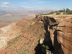
Simply a perfect combination of slickrock and single-track riding. You are also on the top of a mesa with stunning views of Zion and all of southwestern Utah, none-the-less. The interconnected trails system varies in technical difficulty so that you can make a suitable loop ride of almost any length for anyone from beginner to experienced thrill-seeker. Never a crowd.


    Check out the Triplogs.
    Leave No Trace and +Add a Triplog after your mountain bike ride to support this local community.
    WARNING! Hiking and outdoor related sports can be dangerous. Be responsible and prepare for the trip. Study the area you are entering and plan accordingly. Dress for the current and unexpected weather changes. Take plenty of water. Never go alone. Make an itinerary with your plan(s), route(s), destination(s) and expected return time. Give your itinerary to trusted family and/or friends.

     Permit $$
    None


     Directions
    or
     Road
    FR / Jeep Road - Car possible when dry

    To mountain bike ride
    From St. George, travel north on I-15 to the exit for UT-9 (Hurricane/Zion NP). Travel east on UT-9 thorough Hurricane. In town, turn right on UT-59 -- do not follow the signs toward Zion where UT-9 and UT-59 split. Travel east on UT-59 for approx 14.4 miles. Turn left on Smithsonian Butte Rd, which has a Backcountry Byway sign. Continue down this road approx 2.8 miles and turn left onto Gooseberry Mesa Road. Gooseberry Mesa Rd generally has a sign now, but this is not always the case so keep track of the mileage! After approx 3.6 miles, you will reach a major Y with a bathroom and posted trail map. You can park here or go left for another 1.1 mile to the main parking area. You can also go right at the Y to the Windmill trail head.
    page created by autumnstars on Sep 19 2011 12:42 pm
     90+° 8am - 6pm kills
    helpcorrectionissue

    end of page marker