username
X
password
register
for free!
help


Peak 2191 - Hieroglyphic Mtns, AZ

Guide 8 Triplogs  0 Topics
  3 of 5  
Fav
Wish
1
details
drive
no permit
forecast
route  
stats
photos
triplogs
topics
location
30 8 0
Statistics
tap row or icons for details
Difficulty 2 of 5
Route Finding 3 of 5
Distance Round Trip 1.5 miles
Trailhead Elevation 1,800 feet
Elevation Gain 338 feet
Accumulated Gain 364 feet
Kokopelli Seeds 3.32
 Interest Off-Trail Hiking & Peak
feature photo
Photos Viewed All MineFollowing
Inaugural Calculation on Button Tap!
23  2022-02-27
Hieroglyphic Pikes Peak - 3465 - 2191 - Mill
John10s
5  2019-01-05 BobP
7  2012-01-18 leonesiegel
6  2011-12-09 burntlizard
12  2011-11-08 burntlizard
Author
author avatar Guides 16,843
Routes 17,472
Photos 24
Trips 1 map ( 6 miles )
Age 28 Male Gender
Location HAZ, TrailDEX
Associated Areas
list map done
Phoenix Region
Historical Weather
Trailhead Forecast
Radar Map
Expand Map
Preferred Feb, Jan, Dec, Mar
Sun  6:06am - 6:50pm
Official Route & 2 Rts
 
1 Alternative


remove free decal offer

 
Guide Needed
Publish Full Detail Guide


Use +Add above to share photos and triplogs
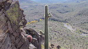
Overview: Short, partially off-trail hike to a small desert peak overlooking Lake Pleasant, the Hieroglyphic Mountains and views beyond.


    Check out the Official Route and Triplogs.
    Leave No Trace and +Add a Triplog after your hike to support this local community.
    WARNING! Hiking and outdoor related sports can be dangerous. Be responsible and prepare for the trip. Study the area you are entering and plan accordingly. Dress for the current and unexpected weather changes. Take plenty of water. Never go alone. Make an itinerary with your plan(s), route(s), destination(s) and expected return time. Give your itinerary to trusted family and/or friends.

     Permit $$
    None


     Directions
    or
     Road
    Paved - Car Okay

    To hike
    2011-11-08 burntlizard From Phoenix, take I-17 north to the Carefree Highway (SR 74). Turn left on Carefree highway and drive West to Castle Hot Springs Rd (Lake Pleasant exit). Turn North and drive for approximately 5 miles to a large pull off on the left side of the road. Careful of deep sand in the parking area. The hike begins at the northwest corner of the parking lot on the other side of a fallen barbed-wire fence.
    page created by hippiepunkpirate on Sep 24 2011 1:15 pm
     90+° 8am - 6pm kills
    helpcorrectionissue

    end of page marker