Route Editor

| Guide | ♦ | 6 Triplogs | 0 Topics |
details | drive | no permit | forecast | route |
stats |
photos | triplogs | topics | location |
| 15 | 6 | 0 |
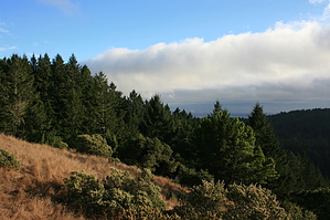
Preferred Method to See Muir Woods by JimmyLyding A hiker's preferred method of enjoying Muir Woods results in only a brief encounter with the tourist hordes. Continue along the Panoramic Highway past the turnoff to Muir Woods to the ample parking near the Mountain Home Inn and the California Alpine Club, and you'll get to enjoy the redwoods in addition to spectacular views and relative solitude. The 1/4 mile stretch of the Panoramic Hwy between the Mountain Home Inn and the California Alpine Club boasts 1 large parking lot and 2 smaller ones, and these provide trail access.
Lost Trail travels 0.5 mile from the junction to Fern Creek. The last few hundred yards are a steep descent on stairs, and the gloom is palpable. This is your first glimpse of a classic canyon bottom redwood community. Immense redwoods grow about 50 feet from each other, and most other vegetation struggles to find enough sunlight to eke out a living. California hazel, canyon gooseberry, and especially poison oak are present, and there are a few bigleaf maples that are difficult to see unless they're showing off their golden fall colors. Do not be alarmed to see tourist types wearing loafers and/or carrying purses (this is California, after all) because you are now amongst the hordes. Go left (south) on the Fern Creek Trail for 0.4 mile to Redwood Creek while ignoring people trying to skip rocks in a creek that's 6" deep or taking pictures of their buddies in "goose pens." A goose pen occurs when dead vegetation accumulates around the base of a redwood that catches fire. The fire roasts a portion of the redwood's base, and the redwood then discards the dead portion of the base which usually results in a small "cave" that it grows around. Goose pens are seemingly irresistible camera magnets: buddy stands in the goose pen and you snap a picture. Early European settlers allegedly used these tree caves to corral geese. You will assuredly see a lot of people on the paved trails around Redwood Creek, but try to focus on the magnificent old growth redwoods. Go right (west) on the paved trail for 0.2 mile to a bridge directing you to the Ben Johnson Trail which is NOT named after the disgraced Canadian sprinter. Ben Johnson immediately begins to ascend the south side of Redwood Canyon, and the hoi polloi quickly become a memory. This trail travels 1.0 mile from Redwood Creek through an increasingly open forest of redwood, Douglas fir, California bay, and tanoak. You gain 720 feet elevation from the canyon bottom to Ben Johnson's junction with a short connector trail south to the Dipsea Trail. The 0.2 mile connector switchbacks up to the Dipsea Trail and the Deer Park Ridge fire road. To this point you have descended 860 feet and ascended 750 feet, but you still have 400 more to go before reaching your turnaround point. The Dipsea Trail and Deer Park Ridge fire road intersect at numerous spots, but it's easy to remain on the Dipsea as you turn right (west). Stay on Dipsea for 0.4 mile as it travels through a forest of Douglas fir that sometimes impersonates rain due to the amount of moisture it accumulates from the fog blowing in off the Pacific Ocean. You will enjoy either spectacular views or dense, blowing fog when you reach the Coast View Trail. There are a few nice rocks to rest on in addition to a bench here on top of the ridge that flows from the Pantoll Ranger Station (approx. 1 mile north) south to the coast. Views are spectacular if it's clear: the dense forest on the western flanks of Mount Tam, the Pacific Ocean spreading out 1300 feet below you, San Francisco to the south, and frequently fog rolling over the coast. However, if the fog is really going you are liable to enjoy wet, thick clouds blasting into your face as it did yesterday (September 24, 2011). Return on the Dipsea Trail to the east for 2.2 miles as it gently meanders down Deer Park Ridge. Dipsea frequently intersects the Deer Park Ridge fire road and joins it for stretches, but signage is superb. There are great views south of Kent Canyon and Redwood Creek as it nears its mouth at Muir Beach. You reach Redwood Creek after these 2.2 miles, and go left (west) to the Muir Woods HQ. You get a good view of the titanic parking lots near the visitor center, but make time to stop by the center because it's one of the better ones. Great book selection. Muir Woods Nat'l Monument is currently reconstructing some of its trails so getting to the Ocean View Trail, the route back to your car, so pay attention to signage. I had to hike up the Hillside Trail (a trail on a raised deck), then go back 200 yards along the trail on the north side of Redwood Creek to access Ocean View. Ocean View gradually ascends 790 feet back to the parking areas along Panoramic Hwy. Check out the Official Route and Triplogs. Leave No Trace and +Add a Triplog after your hike to support this local community. | ||||||||||||||||||||||||||||||||||||||||||||||||||||||||||||||||||||||||||||||||||||||||||||||||