 Route Editor

| Guide | ♦ | 23 Triplogs | 0 Topics |
details | drive | permit | forecast | route |
stats |
photos | triplogs | topics | location |
| 25 | 23 | 0 |
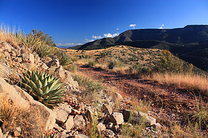
Before highways and railroads... by PrestonSands   Overview OverviewThis hike follows the four-wheel-drive route of Forest Road 503A, a remnant of the 1883 wagon road that linked Jerome with Prescott. The route contours along the eastern slopes of Woodchute Mountain and features the entire Verde Valley area's fine views. F.Y.I. The northern end of FR 503A (near the Jerome Grande Mine) appears to cross Freeport-McMoRan mine property, although there are usually no signs indicating this.
Option 1 (recommended): The shuttle hike Hike from the south end of FR 503A at Mescal Gulch on Highway 89A to the north end of FR 503A at the Jerome Grande Mine on Highway 89A. Stats for this option: 5.5-miles, 901 AEG Option 2: The round trip hike Start at the south end of FR 503A at Mescal Gulch on Highway 89A and hike to the hilltop just east of the 6277' saddle, returning the same way. Stats for this option: 9.1-miles, 1294 AEG Option 3: The loop hike Hike from the south end of FR 503A at Mescal Gulch on Highway 89A to the north end of FR 503A at the Jerome Grande Mine on Highway 89A. Carefully (!) walk back along Highway 89A to your starting point. Stats for this option: 8.2-miles, 1344 AEG History In 1876, mining claims were staked atop a rich deposit of copper, near the present-day town of Jerome. In 1883, some of these claims were bought and consolidated as the United Verde Mine. Frederick Thomas, manager of the newly formed United Verde Mine, was in charge of constructing a wagon road to the isolated mine. Thomas constructed one road going north to Ash Fork, and another going west over the Black Hills to Prescott. The rough road to Prescott was quite steep in places, requiring a log brake to be pulled behind the wagon wheels to prevent runaways. Wagons brought black cinder-like fuel known as coke to the mine for use in the United Verde smelter. Smelted copper was hauled out by wagon on the return trip. Subsequent mine owner William Clark replaced the erosion-prone wagon road in 1894 with the United Verde and Pacific Railroad, which contoured along the northern slopes of Woodchute Mountain. The wagon road became utterly obsolete with the completion of U.S. Highway 89A in 1926. Today, most of the wagon road has been reclaimed by nature, except for Forest Road 503A (this hike). Hike The signed, southern end of Forest Road 503A begins at milepost 339.15 on Highway 89A. There is parking here and at a small campsite a few hundred feet up FR 503A. Follow FR 503A up the canyon into a shady ponderosa pine forest. Three lesser side roads are encountered in the first 0.6 miles; stay left at the first two, and right at the third. Shortly after the third side road, FR 503A crosses the creek bed and doubles back onto the canyon's north side, continuing to ascend and eventually topping a ridge, where it then descends to a four-way road junction at 1.33-miles. Hang a left at this junction; you are now on the route of the historic wagon road. The wagon road (still FR 503A) contours along the wooded eastern slopes of Woodchute Mountain high above Hull Canyon for the next few miles, affording fine views of the Verde Valley and Mingus Mountain along the way. The wagon road arrives atop Woodchute Mountain's prominent east ridge at 4-miles, where it meets the Section House trail 500E coming in from the north (a worthy side hike if you have the time). The wagon road travels east along the ridge through grey limestone bedrock, grass, and agaves, dropping down to the 6277' saddle at 4.6-miles. At this point, one can return the way they came, or continue on FR 503A. I recommend climbing one of the small hills to the east of the saddle for a view into the United Verde Mine's abandoned open pit. If you are continuing... From the 6277' saddle, FR 503A leaves the wagon road's route behind and descends a side canyon to the south, reaching Highway 89A near the Jerome-Grande Mine in 0.9-miles. Return the same way or take the highway back. Camping There are several potential ridge top campsites along the route. Check out the Official Route and Triplogs. Leave No Trace and +Add a Triplog after your hike to support this local community. One-Way Notice This hike is listed as One-Way. When hiking several trails on a single "hike", log it with a generic name that describes the hike. Then link the trails traveled, check out the example. | ||||||||||||||||||||||||||||||||||||||||||||||||||||||||||||||||||||||||||||||||||||||||||||||||||||||||||||||||||||||||||||||||||||||||||||||||||||||||||||||||||||||||||||||||||||||||||||||||||


