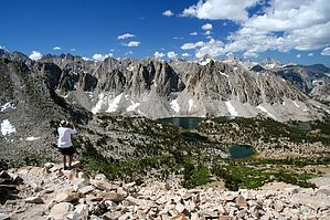
This trip can be the first leg of a longer trip into Kings Canyon National Park and the Rae Lakes area. Although there is a lot of climbing to get over Kearsarge pass, our group did fine with a night at Onion Valley Campground to get a bit acclimated. As you hike up, you will pass several waterfalls, alpine lakes and fantastic peaks. The trail is very high quality and very steady. About halfway up is Gilbert Lake / Flower lake which can make a good point for a mid morning break. Beyond this point the vegetation becomes thinner and thinner. You eventually reach Kearsarge pass about 4 miles from the trailhead. The views from this point are fantastic as well. You'll see the Kearsarge Pinnacles as well as your destination, the Kearsarge Lakes. This is the entrance to Kings Canyon National Park. If day hiking, this can be a good turnaround point.
As you descend through steep rocky terrain, you will come to a signed junction, take the path to the left to head down towards Kearsarge Lakes and Bullfrog Lake (no camping). The upper path is a more direct path towards Charlotte lake or Rae Lakes. Taking the path towards Kearsarge Lakes you will come to an unsigned junction, take the left path again to go to Kearsarge Lakes. There are numerous nice campsites in the area, although you will probably have neighbors. The scenery is fantastic from here.
Bear canisters are required in Kings Canyon although we never saw any signs of activity int he 3 nights we spent in the area. This also is a good base to build to a longer trip in the area. We did a trip to Charlotte lake, then returned to Matlock Lake and back to Onion Valley.
When hiking several trails on a single "hike", log it with a generic name that describes the hike. Then link the trails traveled, check out the example.
WARNING! Hiking and outdoor related sports can be dangerous. Be responsible and prepare for the trip. Study the area you are entering and plan accordingly. Dress for the current and unexpected weather changes. Take plenty of water. Never go alone. Make an itinerary with your plan(s), route(s), destination(s) and expected return time. Give your itinerary to trusted family and/or friends.
To hike From Phoenix: I-10 West to San Bernardino, North on 395 to Lone Pine. Pick up permits in Lone Pine, North on 395 to Independence, left on Market Street (Onion Valley Road) 13 miles to Onion Valley Campground
 Route Editor


