username
X
password
register
for free!
help


Chaol Falls, AZ

Guide 1 Triplog  0 Topics
  5 of 5  
Fav
Wish
4
details
drive
permit
forecast
route  
stats
photos
triplog
topics
location
45 1 0
HAZ reminds you to respect the ruins. Please read the Archaeological Resources Protection Act of 1979 & Ruins Etiquette
Statistics
tap row or icons for details
Distance Round Trip 10 miles
Trailhead Elevation 5,274 feet
 Interest Ruins, Historic, Perennial Waterfall & Perennial Creek
unreported if dogs are allowed
editedit > ops > dogs to adjust
feature photo
Photos Viewed All MineFollowing
45  2011-10-10 PaleoRob
Author
author avatar Guides 16,843
Routes 17,472
Photos 24
Trips 1 map ( 6 miles )
Age 28 Male Gender
Location HAZ, TrailDEX
Associated Areas
list map done
Northeast Region
Historical Weather
Trailhead Forecast
Radar Map
Expand Map
Preferred Apr, Oct, May, Mar
Sun  5:59am - 6:48pm
Official Route
 
0 Alternative


remove free decal offer

 
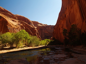
The Chaol Falls route for this guide page is on the Navajo Nation and is off-limits to non-Navajos most of the time. If you have a Navajo friend or guide AND have the permission of the leaseholder, it is possible to visit the falls. The leaseholder will usually charge a fee of between 20-25 dollars per group. If you cannot contact the leaseholder and do not have a Navajo friend or guide (or are not Navajo yourself), DO NOT DO THIS HIKE.


2018-07-14 HAZ_Hikebot


    Check out the Official Route and Triplog.
    Leave No Trace and +Add a Triplog after your hike to support this local community.
    WARNING! Hiking and outdoor related sports can be dangerous. Be responsible and prepare for the trip. Study the area you are entering and plan accordingly. Dress for the current and unexpected weather changes. Take plenty of water. Never go alone. Make an itinerary with your plan(s), route(s), destination(s) and expected return time. Give your itinerary to trusted family and/or friends.

     Permit $$
    information is in description

    Navajo Nation Reservation
    Navajo Permits & Services
    navajonationparks.org


     Directions
    or
     Road
    FR / Jeep Road - Car possible when dry

    To hike
    From Page, drive south on US98 towards Kaibeto. Just past LeChee Rock and Mountain Sheep Rocks, there is a turn on the left. This will take you to the leaseholder's ranch. The leaseholder can provide further directions from there.
    page created by PaleoRob on Oct 12 2011 8:18 am
     90+° 8am - 6pm kills
    helpcorrectionissue

    end of page marker