|
tap row or icons for details
|
| Distance Round Trip |
|
0 miles |
| Trailhead Elevation |
|
196 feet |
| Interest Off-Trail Hiking | | unreported if dogs are allowed
editedit > ops > dogs to adjust |
| | |
|
|
28 |
2014-02-16 |
Colorado River - Walter's Camp to Squaw Lake |
azbackpackr |
|
|
|
10 |
2009-07-02 | gummo |
|
|
10 |
2009-06-04 | gummo |
|
| |
|
|
|
list |
map |
done |
Inland Region |
| | |
|
| |
|
|
Historical Weather |
| Trailhead Forecast | | |
|
 |
|
|
| Preferred Dec, Jan, Feb, Nov |
|
|
| | |
| |
Named Locations Coordinate Links
| |
|
| Picacho State Recreation Area
|
3.9 mi
115 ft |
|
|
| Colorado River - Walter's Camp to...
|
41.94 mi
264 ft |
|
|
| | |
| |
|
|
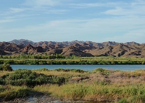
 Overview: Overview: Picacho State Recreation Area is located on the lower Colorado river at the site of Picacho, a defunct gold mining town. Now it's over-run by wild burros left over by the miners. The park offers diverse scenery, including beavertail cactus, bighorn sheep, desert tortoises, coyotes, foxes, beavers, speckled rattlesnakes, and thousands of migratory waterfowl. The park is on one leg of the Pacific Flyway. Eight miles of the lower Colorado River are the recreation area's eastern border. Most people are there to fish. Day use, fishiing, and campground are open all day and night. First-come first-served camping, contact the park directly for information and fees - 760-996-2963. Driving to the park is possible in a car risky due to the loose sand, especially after a storm. AWD or 4x4 is recommended. |
 Route Editor