 Route Editor

| Guide | ♦ | 3 Triplogs | 0 Topics |
details | drive | permit | forecast | map |
stats |
photos | triplogs | topics | location |
| 15 | 3 | 0 |
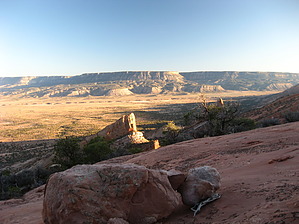
Finding the trail is the hardest part! by Jim   Overview OverviewSkeleton Mesa is the large mesa to the west of Kayenta, north of US 160, and north of Marsh Pass. This area is west of Kayenta, approximately near the Anasazi Inn. It is similar to Black Mesa, but geologically very different, and it has had less human intrusion than Black Mesa. Unlike Black Mesa, there do not appear to be roads on Skeleton Mesa, and there has not been any clearing of the vegetation for grazing. There is also no coal mine! There is a trail that ascends a ramp on the eastern side of the mesa, and once found, the route is pretty easy to follow, but finding the trail is the hard part. However, if you have been there once, it should be pretty easy to find. Hike From the parking area or trailhead, hike cross-country west towards the large ramp, or monocline, that can be seen to connect with the mesa. This ramp is distinctive and maybe the only part of the intact monocline to reach the mesa top. This image looks at the ramp. As you hike west, you will reach a small graded (when I met it) road. Depending on where you are, you will want to follow it north for a short time to reach a small seldom used, but noticeable, two-track on the west side of the graded road. If you take this two-track, you can go directly to the trailhead where the tracks loop around at the trail base. If you can't find them or have met the better maintained graded road north of the two-track, good luck. Things change out here, and unfortunately, details are hard to pin down. Coordinates are the best way for an outsider to access the area. The road junction is not visible on the satellite image, nor is the trailhead, but I interpreted the trail end (I met it going down) to be roughly: 36.74356, -110.39143. Hopefully, that helps, and you are not completely lost. You have to know where you are going and have some sense of direction. I found the trail by accident but had an easy time getting close to it. Coming down was essentially a breeze.
OK, let's pretend you had an easy time finding the trail and are now hiking up. You have it pretty easy and can follow it as it ascends to the top of Skeleton Mesa. The top can be considered the large sandstone area near the group of Ponderosa Pines. The trail continues to the pinyon and sage-covered mesa, but again, finding it is hard unless you know the way. There are erosion gullies, and they look like trail at times. If you found it, the trail crosses over the mesa to Utah, I am told, but I know nothing more about it once you are about 1/4 mile beyond the Ponderosa Pines. Return the way you came, and hopefully, you'll have an easy time hiking down. I did and went right to my car, but that was partly due to me following my footsteps. Check out the Triplogs. Leave No Trace and +Add a Triplog after your hike to support this local community. | |||||||||||||||||||||||||||||||||||||||||||||||||||||||||||||||||||||||||||||||||||


