Route Editor

| Guide | ♦ | 4 Triplogs | 0 Topics |
details | drive | permit | forecast | map |
stats |
photos | triplogs | topics | location |
| 54 | 4 | 0 |
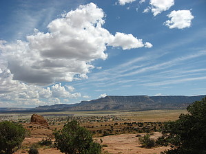
End of the Comb Monocline by Jim   The Toes, as they are locally known, are the furthest southwest extension of the Comb Ridge, or Comb Monocline. They sit above old town Kayenta off of US 163 and behind the Wetherill Inn, Kayenta Elementary School, and the Indian Health Service Housing. Views are pretty good, and to the south is Kayenta, Black Mesa, and a vast plain, known as the Chinle Valley, which stretches well beyond the visible Corrizo and Chuska Mountains. This plain extends south of Canyon De Chelly, the Defiance Uplift, Interstate 40, and goes all the way to the White Mountains, if you care to know, but you'll never see that far away. Skeleton Mesa Dominates the western view, and between Skeleton and Black Mesa is Marsh Pass. To the north are Laguna Creek and a basin with sedimentary layers you'll encounter commonly around Mexican Hat, UT. Monument Valley is only slightly visible. On a good day, you can see higher terrain in Utah and Colorado, as well. The Toes, as they are locally known, are the furthest southwest extension of the Comb Ridge, or Comb Monocline. They sit above old town Kayenta off of US 163 and behind the Wetherill Inn, Kayenta Elementary School, and the Indian Health Service Housing. Views are pretty good, and to the south is Kayenta, Black Mesa, and a vast plain, known as the Chinle Valley, which stretches well beyond the visible Corrizo and Chuska Mountains. This plain extends south of Canyon De Chelly, the Defiance Uplift, Interstate 40, and goes all the way to the White Mountains, if you care to know, but you'll never see that far away. Skeleton Mesa Dominates the western view, and between Skeleton and Black Mesa is Marsh Pass. To the north are Laguna Creek and a basin with sedimentary layers you'll encounter commonly around Mexican Hat, UT. Monument Valley is only slightly visible. On a good day, you can see higher terrain in Utah and Colorado, as well.One nice thing about this area is even though it is on the Navajo Reservation, it's open to the public as a recreation area for the IHS staff, so you don't need to concern yourself with a Navajo Recreation Permit if you normally would do such things. The hook is that due to the parking being on IHS grounds and the gate being opened and closed daily by the Clinic Security, you'll want to be out before dark, and it may be best to check in with the Clinic Security to find out when they plan to lock the gate that particular day. I have been told it is open every day, but during daylight hours only. Still, it wouldn't be hard to jump over the fence if locked out. Because this hike requires no permits, it may be perfect for someone passing through the area or visiting Monument Valley and looking for something to do before or after their visit.
Your trip will depend on what you do and where you go. The description Stats reflect a straight shot to the true summit and back, with no other exploration. Record appropriately and return to your car parked at the gate. Gate Policy: If a gate is closed upon arrival, leave it closed after you go through. If it is open, leave it open. Leaving a closed gate open may put cattle in danger. Closing an open gate may cut them off from water. Please be respectful, leave gates as found. The exception is signage on the gate directing you otherwise. Check out the Triplogs. Leave No Trace and +Add a Triplog after your hike to support this local community. | |||||||||||||||||||||||||||||||||||||||||||||||||||||||||||||||||||||||||||||||||||