|
tap row or icons for details
|
| Distance One Way |
|
4 miles |
| Trailhead Elevation |
|
13 feet |
| unreported if dogs are allowed
editedit > ops > dogs to adjust |
| | |
|
|
|
list |
map |
done |
Central Region |
| | |
|
| |
|
|
Historical Weather |
| Trailhead Forecast | | |
|
 |
|
|
| Preferred Jan, Dec, Feb, Nov |
|
|
| | |
| |
Named Locations Coordinate Links
| |
|
| help future hikers |
| post a gps route now |
| | |
| |
|
|
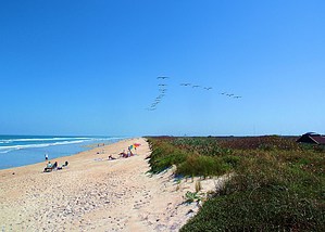
 Overview: Overview: Playalinda Beach (Playa Linda - Spanish for "pretty beach") is a beach located on Florida's east coast in Canaveral National Seashore. When translated from Spanish, Playa linda is "pretty beach". The beach is open to the public daily between 6:00 am to 6:00 pm in the winter and 6:00 am to 8:00 pm in the summer. Playalinda Beach is on a barrier island separate from the mainland by the Indian River. Canaveral National Seashore's 24 miles (39 km) of shoreline is the longest stretch of undeveloped public beach on the east coast of Florida. The stretch of drivable beach is just over 4 miles (6.4 km). The barrier island is a thin ribbon of sand lying between the ocean and Mosquito Lagoon. In some places it is no more than 100 yards (91 m) wide. Unlike many barrier islands with primary and secondary dunes, Playalinda has only a single dune. The island provides an important buffer against tropical storms and hurricanes, absorbing the initial brunt of wind and waves. One-Way NoticeThis hike is listed as One-Way. When hiking several trails on a single "hike", log it with a generic name that describes the hike. Then link the trails traveled, check out the example. |
 Route Editor


