username
X
password
register
for free!
help


Walnut Canyon via Battle Axe Rd, AZ

Guide 7 Triplogs  1 Topic
  4.5 of 5  
Fav
Wish
0
details
drive
permit
forecast
map
stats
photos
triplogs
topic
location
66 7 1
Statistics
tap row or icons for details
Distance Round Trip 21.1 miles
Trailhead Elevation 3,001 feet
 Interest Off-Trail Hiking
unreported if dogs are allowed
editedit > ops > dogs to adjust
feature photo
Photos Viewed All MineFollowing
13  2018-01-23
Gila River Canyons - AZT #16
topohiker
8  2016-03-19
Gila River Canyons - AZT #16
topohiker
50  2015-10-31
The Rincon Battle Axe Butte Loop
CannondaleKid
11  2012-12-20
Artisan Well- Martinez - Coke Oven -Loop
topohiker
25  2012-11-10 CannondaleKid
1  2012-04-17 Sredfield
15  2011-12-07 CannondaleKid
20  2011-11-11
Coke Ovens via Battle Axe
CannondaleKid
Page 1,  2
Author
author avatar Guides 16,843
Routes 17,472
Photos 24
Trips 1 map ( 6 miles )
Age 28 Male Gender
Location HAZ, TrailDEX
Historical Weather
Trailhead Forecast
Expand Map
Preferred Nov, Apr, Mar, Oct → 7 AM
Sun  6:00am - 6:46pm
2 Routes
 
0 Alternative


remove free decal offer
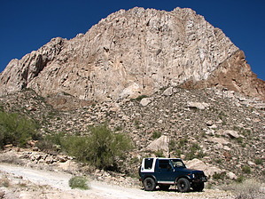
Action Whack
by HAZ_Hikebot

 
The first and last 5 miles are on the relatively easy but sometimes rough Battle Axe Road. The actual 10-mile Walnut Canyon loop is VERY rough, rocky with plenty of washouts. due to some steep sections with tenuous traction, I would only recommend a short-wheelbase high-clearance 4x4 vehicle with a rear locker. The beginning and end of the Walnut Canyon loop is at: 33.15028 -111.09315


2018-07-14 HAZ_Hikebot


    Check out the Triplogs.
    Leave No Trace and +Add a Triplog after your 4x4 trip to support this local community.
    WARNING! Hiking and outdoor related sports can be dangerous. Be responsible and prepare for the trip. Study the area you are entering and plan accordingly. Dress for the current and unexpected weather changes. Take plenty of water. Never go alone. Make an itinerary with your plan(s), route(s), destination(s) and expected return time. Give your itinerary to trusted family and/or friends.

     Permit $$

     Directions
    or
     Road
    Strictly 4x4

    To 4x4 trip
    Take US 60 to the east end of Superior, turn right (south) on AZ 177, and follow it to a point .9 mile PAST mile marker 159. Turn right (west) onto the dirt Battle Axe Road.

    Once on Battle Axe Road be sure to turn right immediately after the cow pens and continue for a total of 5.4 miles from SR 177. When you reach the coordinates 33 09.031 -111 05.592 where you will turn left onto unmarked Walnut Canyon Road.
    page created by CannondaleKid on Nov 10 2011 10:45 am
     90+° 8am - 6pm kills
    helpcorrectionissue

    end of page marker