username
X
password
register
for free!
help
 
  🔥

Bear Head Mountain Loop - Sierra Ancha, AZ

Guide 2 Triplogs  0 Topics
  5 of 5  
Fav
Wish
2
details
drive
no permit
forecast
🔥
route  
stats
photos
triplogs
topics
location
63 2 0
Canyons are inherently risky. Flash floods occur without notice on sunny days. Technical skills & surrounding topography knowledge required yet does not eliminate risk.
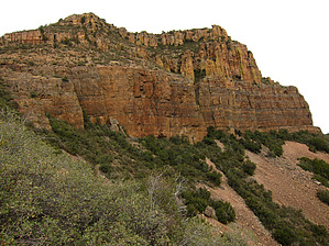
HAZ reminds you to respect the ruins. Please read the Archaeological Resources Protection Act of 1979 & Ruins Etiquette
Canyoneering
Consensus
View 1
Grade2
WaterA
Risk
TimeIII
Statistics
tap row or icons for details
Difficulty 3.5 of 5
Route Finding 3 of 5
Distance Round Trip 3.4 miles
Trailhead Elevation 4,707 feet
Elevation Gain 1,332 feet
Accumulated Gain 1,632 feet
Kokopelli Seeds 11.56
 Interest Off-Trail Hiking, Ruins, Seasonal Waterfall & Seasonal Creek
 Dogs not allowed
feature photo
Photos Viewed All MineFollowing
Inaugural Calculation on Button Tap!
12  2011-11-11 ssk44
51  2011-11-11 Grasshopper
Author
author avatar Guides 16,843
Routes 17,472
Photos 24
Trips 1 map ( 6 miles )
Age 28 Male Gender
Location HAZ, TrailDEX
Historical Weather
Trailhead Forecast
Radar Map
Expand Map
Preferred Nov, Dec, Apr, May
Sun  6:00am - 6:46pm
Official Route
 
1 Alternative
 
Historic Fire Perimetersacres
🔥 Picture 200339.9 mi*
🔥 2012 Mistake Peak Fire5.2k
🔥 2003 Picture Fire12.5k
🔥 2003 Picture35.2 mi*
🔥 View (All) - over Official Route 🔥
*perimeter length in miles


remove free decal offer

 
Overview
A serious intermediate route-finding and bushwhacking off-trail hike to traverse the lower cliff face of rugged Bear Head Mountain (located in the Sierra Ancha Mountains) to view one visible ancient, partially walled Indian Ruin with "possible" other significant cliff dwelling along its higher NE cliff ledges not viewable or reachable without canyoneering expertise. This hike also includes an option as an out and back from this hikes posted GPS tack NE waypoint (labeled BearHDMtn-DOWN--> 33.92502 -111.11520) or a recommended loop hike to off-trail then enter upper Malicious Gap-Greenback Creek canyoneering route (at waypoint 33.92664 -111.11163) to end back down at the Bear Head Mountain/Malicious Gap TH Start.

2018-07-14 HAZ_Hikebot


    Check out the Official Route and Triplogs.
    Leave No Trace and +Add a Triplog after your canyon trip to support this local community.
    WARNING! Hiking and outdoor related sports can be dangerous. Be responsible and prepare for the trip. Study the area you are entering and plan accordingly. Dress for the current and unexpected weather changes. Take plenty of water. Never go alone. Make an itinerary with your plan(s), route(s), destination(s) and expected return time. Give your itinerary to trusted family and/or friends.

     Permit $$
    None


     Directions
    or
     Road
    Strictly 4x4

    To canyon trip
    From the Phoenix area: See driving directions from the "Malicious Gap" hike description and also see posted Driving Directions GPS track for this hike description;
    page created by Grasshopper on Nov 13 2011 10:27 am
     90+° 8am - 6pm kills
    helpcorrectionissue

    end of page marker