Route Editor

| Guide | ♦ | 20 Triplogs | 0 Topics |
details | drive | no permit | forecast | map |
stats |
photos | triplogs | topics | location |
| 215 | 20 | 0 |
Canyons are inherently risky. Flash floods occur without notice on sunny days. Technical skills & surrounding topography knowledge required yet does not eliminate risk.
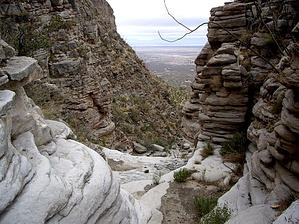
Bad Start...Good Finish! by imike  Park at the trailhead for Trail 104 (The city water system at the upper end of Alamo Canyon Road) and make your way cross country over to the mouth of the canyon just to the north. You can cross the private land directly adjacent to the water facility, or move up the hill 100' and cross the fence into National Forest land, then follow the fence line to the canyon drainage. This is not a fun traverse, but neither is it too difficult.
I was welcomed on my exploratory hike by a small coral snake and a grouping of 12-15 Big Horn Sheep, typical to the 5,000' level of these canyon mouths. The canyon splits less than a mile from the beginning. I took the right fork. It offered up a nice variety of rock then finally a 60' waterfall, pleasantly climbable, but the first forty feet are fully exposed. If you slip you will fall the full forty feet to the bottom. In general the progress up the canyon was stair step waterfalls with great side views of the surrounding convoluted and striated rock walls. The rock side cliffs are impressive. Not too far above the big falls, the canyon narrowed then spread out into a broad upper meadow. I moved left and out across the dividing ridge between the two forks of the canyon. Gazing down into the left hand branch of the drainage I realized that it was the main part of the canyon, topping out substantially higher up, accessing The Mesa. That branch was more open, with long stretches of solid rock walkways... appealing, but not worth missing the big fall for? I'll have to check that out another day. I continued on up onto and across The Mesa to descend Goat Springs Trail. Shorter options would have been down the next drainage to the north, RockaChucky, or around and down The Gap. From my house, 1.5 miles away from the trailhead, and including the loop across The Mesa, down Goat Springs trail, then the walk back home (...another 1.5 miles) the hike only used up six hours at an easy pace. Pock Rock Canyon was a very pleasant discovery; not for everyone, but for those looking for a bit of a change with a touch more challenge, yet shorter... possibly ideal. Again, this drainage felt more dangerous. Caution should be exercised. Do as I say, not as I do! Check out the Triplogs. Leave No Trace and +Add a Triplog after your canyon trip to support this local community. | |||||||||||||||||||||||||||||||||||||||||||||||||||||||||||||||||||||||||||||||||||||||||||||||||