Peak 3,651 - Hell's Canyon Wilderness, AZ | HikeArizona


Peak 3,651 - Hell's Canyon Wilderness, AZ

Guide 5 Triplogs Mine 0 0 Topics
 
3.7 of 5 
Fav
Wish
0
details
drive
no permit
forecast
map
stats
photos
triplogs
topics
location
7 5 0
Statistics
tap icons for details
Difficulty 3 of 5
Route Finding 3 of 5
Distance Round Trip 2 miles
Trailhead Elevation 2,850 feet
Elevation Gain 801 feet
Accumulated Gain 1,000 feet
Avg Time Round Trip 2 hours
Kokopelli Seeds 7
 Interest Off-Trail Hiking & Peak
 Backpack Yes
unreported if dogs are allowed
editedit > ops > dogs to adjust
feature photo
Photos Viewed All MineFollowing
23  2022-02-12
Hieroglyphic Mtns - 3651 and 3392
LindaAnn
17  2022-02-12
The highpoint of Hell and 3392
The_Eagle
9  2022-02-12
The highpoint of Hell and 3392
BiFrost
6  2020-01-04 toddak
1  2011-11-26 Barrett
Author
author avatar Guides 14
Routes 9
Photos 1,371
Trips 286 map ( 1,559 miles )
Age 59 Male Gender
Location Phoenix, AZ
Associated Areas
list map done
Phoenix Region
Historical Weather
Trailhead Forecast
Expand Map
Preferred Mar, Nov, Feb, Jan
Seasons   Autumn to Spring
Sun  5:32am - 7:20pm
Route
 
1 Alternative
 
 Water
Nearby Area Water
[ View More! ]
no photo labels yet
+Add > Photos to this Guide
then label as applicable
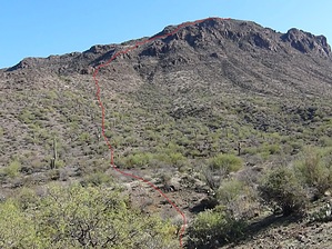
Highest point in Hell
by Barrett

 
From the Burro Flats Trailhead proceed due East down the drainage in the direction of the north saddle of Peak 3651. The going is easy, as cattle and burro in the area have created numerous game trails. Keep your eye out for gold, as there is quite a bit of surface quartz and you just never know. Head up the soft ridge leading to the saddle, if you reach a 4-wire fence strung east-west, you are too far north. I try to stay on the south side of ridges when possible, as the vegetation is usually thinner and travel is easier. Upon reaching the saddle area, follow the summit ridge south to the summit, where I formed a small cairn. There was no summit register, so I placed a card in a plastic bag under the main stone. If you head southeast about a hundred yards, you will find a great slanted stone to cop a rest, complete with shade from a saguaro if the time is just right.The return is along the same route. The rock is fairly stable, the slope moderate, and there is hardly any catclaw or cholla; an off-trail hikers paradise. Vegetation is primarily brittlebush, jojoba, ocotillo, and palo verde. I have seen burro in this area on previous trips, but nothing this time. I would recommend this trail to anyone looking for a fairly easy off-trail peak bag. That being said, you will need a high-clearance vehicle to reach the trailhead, particularly if you are coming up Morgan City Wash. As with any off-trail adventure, I wear mid-weight boots, low-gaiters, ripstop long pants and sleeves, and leather gloves (and a hat if the sun is blazing), sunglasses or clear lenses are also great for keeping thorny brush away from eyeballs. I find there is an inverse correlation between enjoyment and blood loss.

Check out the Triplogs.

Leave No Trace and +Add a Triplog after your hike to support this local community.

2011-11-26 Barrett
    WARNING! Hiking and outdoor related sports can be dangerous. Be responsible and prepare for the trip. Study the area you are entering and plan accordingly. Dress for the current and unexpected weather changes. Take plenty of water. Never go alone. Make an itinerary with your plan(s), route(s), destination(s) and expected return time. Give your itinerary to trusted family and/or friends.

     Permit $$
    None


     Directions
    or
    or
     Road
    High Clearance possible when dry

    To Burro Flats Trailhead
    Route to Garfias/Horse/Burro Trailheads
    From Phoenix head north on I-17 to the Carefree Highway (SR74)

    Two routes are possible, the first preferable for those not in a hurry and driving vehicles with no 4wd and medium clearance. Follow 17 north from Phoenix to the Carefree Highway, head west to Castle Hot Springs Road, take this north approximately 9.7 miles, then left for another 7 miles, during which you will pass the old Castle Hot Springs Resort, an amazing piece of history currently off limits and under reconstruction. The road will stop at a T intersection, turn left ( west ) to continue on Castle Hot Springs Road for another 5.8 miles to unimproved road on your left ( south ). There should be some signage with land usage rules. Take this south for another 2.5 to access the Horse Spring trailhead, then about .8 miles to the Burro Spring Trailhead.

    The second route requires higher ground clearance and possibly 4wd, depending on tire size and tread. It should not be attempted during heavy rains in the area. Instead of turning off Carefree Highway on to Castle Hot Springs road, continue west another 1.3 miles , then turn right and reset your odometer. Head north on the asphalt road leading to the Morgan City Wash, 1.1 miles further. Turn left and head northwest in the bottom of the wash, following the main drainage upward. Ignore the turnoff for #10 to the left after 4.5 miles, continuing on to 5.6 miles to a cattle gate. Pass through and follow the wash until mile 7.7, where you will see a windmill and water tank on your right, immediately after, turn up out of the wash to the right and head northeast. At mile 9.1 you should see a metal trailhead log podium for Burro Springs on your right.

    Both ways require topos for accurate navigation, GPS is helpfull but not necassary.


    Detailed route from 1-17 for car route:
    1) Take the AZ-74 exit 223 to Wickenburg - go 0.4 mi
    2) Continue on W Carefree Hwy toward Wickenburg - go 1.9 mi
    3) Continue on AZ-74 - go 2.1 mi
    4) Continue on W AZ-74 - go 2.4 mi
    5) Continue on N Lake Pleasant Rd - go 2.7 mi
    6) Continue on AZ-74 - go 2.4 mi
    7) Turn right at Castle Hot Springs Rd - go 8.0 mi
    8) Bear left at N Castle Hot Springs Rd - go 1.6 mi
    9) Continue toward N Castle Hot Springs Rd - go 0.4 mi
    10) Continue on N Castle Hot Springs Rd - go 4.7 mi
    11) Turn left at Castle Hot Springs Rd - go 0.9 mi
    12) Turn left at N Castle Hot Springs Rd - go 7.9 mi
    13) Arrive at 33.933300, -112.415900 (Trailhead)
    Please note: The road is frequently closed due to flooding since the creek bed is the road for a section.

    From PHX (I-10 & AZ-51) - 80.0 mi, 2 hours 17 mins
    From TUC (Jct 1-10 & Grant) - 185 mi, 3 hours 57 mins
    From FLG (Jct I-17 & I-40) - 164 mi, 3 hours 26 mins
    page created by Barrett on Nov 26 2011 9:53 am
     90+° 8am - 6pm kills
    Avoid Heat Illness - stay cool
    helpcorrectionissue

    end of page marker