Route Editor

| Guide | ♦ | 12 Triplogs | 0 Topics |
details | drive | no permit | forecast | 🔥 route |
stats |
photos | triplogs | topics | location |
| 124 | 12 | 0 |
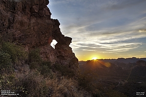
Out of Towners Delight by Yoder  Overview OverviewThis is a very short hike to the Sunset Arch, located on the North-West side of Peak 2625 (AKA Sunset Butte). While the hike is short, it is long in views. Some of the best views of the Superstitions and the Goldfield mountains can be seen here. The trail is very easy to follow with a combination of cairns and rocks lining the path at different sections. My wife calls this a photo-op hike, I consider it a great hike for folks from out of town, who might not be in the best of shape, that will give them a taste of the great Sonoran desert without having to work to hard to see it. Its also an excellent location for a quick sunset/sunrise photo if the clouds are cooperating or an excellent location to capture some photos of the monsoon storms as they roll into the valley.
Hike From the car, follow the dirt road that heads up the hill to the ridge From here you can easily see Sunset Butte where the arch is located. Very shortly after the road turns South there is a small cairn to the east (left) of the road marking the start of the trail. At this point, you have traveled less than 300 feet from your parked vehicle. Follow the trail down the side of the hill into the wash, and continue up the next hill that eventually levels out and goes through a nice little stand of Saguaros. The trail now drops into the next wash, then climbs back out. This is the steepest section of the hike so watch your step. The second wash is about 0.25 miles from the start of the hike. Continuing out of the second wash the trail works its way up the side of the mountain with the angle of ascent decreasing as you progress up the mountainside. Just before you reach the saddle to the North of Peak 2626 you cross through a break in a fence. At this time you should be able to see the arch to the South by following the line of the fence trailing South. Continue to follow the trail to a large boulder. This is a great place for getting a photo of the arch. Wonderful views of the South and West here at the photo boulder, Great views of the East and North in the Saddle area, and if you would like to get a great panoramic view work your way up to the top of the Butte by heading initially West to the back of the Butte, then climbing the butte by heading South-East to the peak(This is currently not marked). Check out the Official Route and Triplogs. Leave No Trace and +Add a Triplog after your hike to support this local community. | ||||||||||||||||||||||||||||||||||||||||||||||||||||||||||||||||||||||||||||||||||||||||||||||||||||||||||||||||||||||||||||||||||||||||||||||||||||||||||||||||||||||||||||||||||||||||||||||