Route Editor

| Guide | ♦ | 29 Triplogs | 0 Topics |
details | drive | no permit | forecast | map |
stats |
photos | triplogs | topics | location |
| 201 | 29 | 0 |
Canyons are inherently risky. Flash floods occur without notice on sunny days. Technical skills & surrounding topography knowledge required yet does not eliminate risk.
Oh, So Very Nice!! by imike  Surprise!
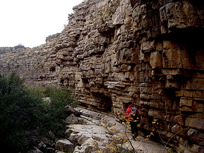
The first section snakes you around and into a narrow defile, terminating in a terraced fall formation. For many this would be the end of the hike, and well worth it if that is all there was. Better option: turn around and return to the first side drainage coming down and in from the north. This is an easily scalable climb that will carry you up to the ridge dividing North and South Ortega Canyons. Follow it along, enjoying the views down into the canyon. The downview of the waterfall is impressive. Moving above and beyond the waterfall, You will notice a large cavatation off the sidewall on the other side of the canyon. There are some fairly easy downclimbs at this point. Make your way back down and into the floor of the canyon and hike downstream towards the fall. You will encounter yet another smaller waterfall that can be downclimbed on the southern edge. It would not be a bad idea to add a rope into that manuever, just for safeties sake. From there, you can hike further down to the lip of the big waterfall. Again... this could be the end of your hike for the day... or... Hike up drainage, enjoying the rock. The canyon soon begins to lose some of the grotto like narrow defile, and opens up, with more and more shrubbery obscuring the route, finally terminating in yet another ledged waterfall. You may exit the canyon on the north side in a variety of places, moving on up into the upper canyon section. I chose to instead enjoy the hike down Ortega Ridge, reviewing the canyon and noting a variety of side drainages worthy of checking out on another day. The upper basin which terminates at the foot of Ortega Peak appears to be overgrown. An easy alternative for a return loop, if you go all the way up to the top of the canyon, would be to hop onto T119, The "A" trail, following it back down into town. The place to park for this hike is at the first set of City Water Tanks at the edge of the lower housing development. The canyon really begins next to the upper tanks, but the narrow road is not conducive to good parking and since you will be crossing private property to begin the hike, best to walk the short distance up the road from the lower tanks. Check out the Triplogs. Leave No Trace and +Add a Triplog after your canyon trip to support this local community. | |||||||||||||||||||||||||||||||||||||||||||||||||||||||||||||||||||||||||||||||||||||||||||||||||||||||