 Route Editor

| Guide | ♦ | 12 Triplogs | 0 Topics |
details | drive | no permit | forecast | map |
stats |
photos | triplogs | topics | location |
| 0 | 12 | 0 |
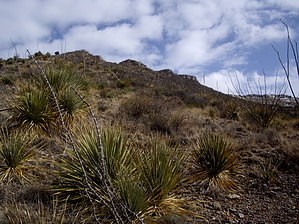
I can get there from here! by imike Once on the Ridge you have fairly open, if often steep, access to range back and forth to enjoy views down into either canyon. You also have options for descending down into the canyon bottoms, but exercise caution. The rock here is often razor sharp, and can be loose and unstable.
This is a nice hike to enjoy on some of the colder winter days when full sunlight exposure is a welcome idea. The hike is all off trail. Exercise care and caution... lots of prickly stuff up there! If you begin this Ridge hike using Ortega Canyon South, please park at the lower city water tank, not near the upper tanks. That area is private property, and you will be crossing private land in the early portion of the hike. Be quiet and respectful to preserve our ongoing access to this area. Check out the Triplogs. Note This is a moderately difficult hike. Leave No Trace and +Add a Triplog after your hike to support this local community. One-Way Notice This hike is listed as One-Way. When hiking several trails on a single "hike", log it with a generic name that describes the hike. Then link the trails traveled, check out the example. | ||||||||||||||||||||||||||||||||||||||||||||||||||||||||||||||||||||||||||||||||||||||||||


