username
X
password
register
for free!
help


Emery Henderson Via New River Rd, AZ

Guide 1 Triplog  0 Topics
  4 of 5  
Fav
Wish
0
details
drive
no permit
forecast
map
stats
photos
triplog
topics
location
25 1 0
Statistics
tap row or icons for details
Distance Round Trip 6 miles
Trailhead Elevation 1,867 feet
 Interest Off-Trail Hiking
unreported if dogs are allowed
editedit > ops > dogs to adjust
feature photo
Photos Viewed All MineFollowing
6  2018-02-10
Lake Pleasant Wander
topohiker
14  2017-11-18
Honeymoon Cove
topohiker
16  2017-02-04 topohiker
9  2011-12-23 burntlizard
Author
author avatar Guides 16,843
Routes 17,472
Photos 24
Trips 1 map ( 6 miles )
Age 28 Male Gender
Location HAZ, TrailDEX
Associated Areas
list map done
Phoenix Region
Historical Weather
Trailhead Forecast
Expand Map
Preferred Feb, Jan, Dec, Mar
Sun  6:05am - 6:49pm
0 Route
 
0 Alternative


remove free decal offer

 
Guide Needed
Publish Full Detail Guide


Use +Add above to share photos and triplogs
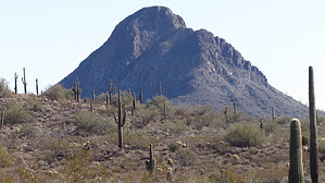
Overview: Nice easy hike with views of the surrounding mountains and a mixture of desert flora. As you head further North the Saguaros become thick and numerous in spots. At 2.50 miles you will see the wooden BCT trail sign, I took the East loop and figured this hike as a round trip, because you'll come to a cattle fence at 3 miles, this should be a nice turn around point for most.


    Check out the Triplog.
    Leave No Trace and +Add a Triplog after your hike to support this local community.
    WARNING! Hiking and outdoor related sports can be dangerous. Be responsible and prepare for the trip. Study the area you are entering and plan accordingly. Dress for the current and unexpected weather changes. Take plenty of water. Never go alone. Make an itinerary with your plan(s), route(s), destination(s) and expected return time. Give your itinerary to trusted family and/or friends.

     Permit $$
    no fees or permits reported

    if incorrect tell us about it


     Directions
    or
     Road
    Connector trail - Not Applicable

    To hike
    Take I-17 North to New River Road. Head West on New River Road 3.1 miles and you will see the parking area and sign on the right. There is plenty of parking and restrooms.
    page created by burntlizard on Dec 23 2011 4:16 pm
     90+° 8am - 6pm kills
    helpcorrectionissue

    end of page marker