Overview
This hike follows both the new and the original Mount Ord roads to the 7128-foot summit of Mount Ord in Arizona's Mazatzal Mountains. Although the entire hike is along a road, you are not likely to encounter much traffic. Certainly not on the lower road, that is an eroded, high clearance, four-wheel-drive jeep trail. This hike can be done as a round trip or as a one way if you set up a shuttle vehicle.
History
Mount Ord seems to be the hub of Mazatzal Mountain history. Early items of note include a "Lost Apache Mine" somewhere on its north slope and the construction of a wagon road to Camp Reno along its south slope in 1868. While the U.S. Army was fighting the Apaches during the 1880s, Mount Ord's summit was the site of a heliograph station. The Army used these tripod mounted mirrors to flash messages to other heliograph sites in the area, such as Mazatzal Peak and Aztec Peak, by reflecting sunlight.
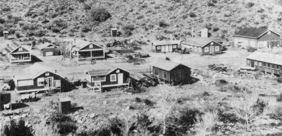
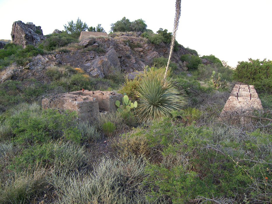
This hike begins at the bottom of Slate Creek, where, in early 1925, prospectors Wesley Goswick, Jess Henderson, and Bill Packard located a rich cinnabar (mercury) deposit. Their claims were purchased and became the Ord Mine. The Arizona Quicksilver Corporation developed the property in 1926 and constructed an ore processing mill with a rotary furnace, on top of a small hill, directly above the Ord Mine. The company blazed a wagon road up Slate Creek to the site, where they also constructed a small town that came to be known as Stalker Village (a.k.a. Goswick Camp). Stalker Village contained a warehouse, office, boarding house, and several houses. The mining boom was short-lived, however, and Stalker Village was abandoned after the Ord Mine and mill shut down in 1932. In subsequent years, the mine reopened several times, and a new mill was constructed closer to Slate Creek. Local character Travis Walton (think "Fire In The Sky") was said to have lived in Stalker Village sometime before new highway construction destroyed it in the 1970s. Nothing remains of Stalker Village, but the Ord Mine and the foundations of its first mill can be seen along this hike.
In 1933, during the height of the Great Depression, the Civilian Conservation Corps, or "C.C.C.," established Sunflower Camp F-25-A at Cane Spring, just north of the Ord Mine. In addition to constructing the Bush Highway (precursor to highway 87) through the Mazatzal Mountains, they also constructed the "Mount Ord Truck Trail" to the summit of Mount Ord, which this hike follows in its entirety. During 1936 and 1937, the Civilian Conservation Corps extended the Ord Mine road from the mill site above the mine to Mount Ord's summit, where they erected a steel fire tower and a cabin for the U.S. Forest Service. The fire tower was replaced in 1983, but the original cabin remains. The original fire tower is now on display at the Rim Country Museum in Payson. The "Mount Ord Truck Trail" was partially bypassed in the 1970s by the new Mount Ord road, Forest Road 626. The deteriorating "Mount Ord Truck Trail," now known as Forest Road 27, is the ideal route for hikers to climb Mount Ord.
Hike
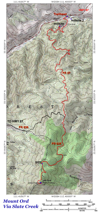
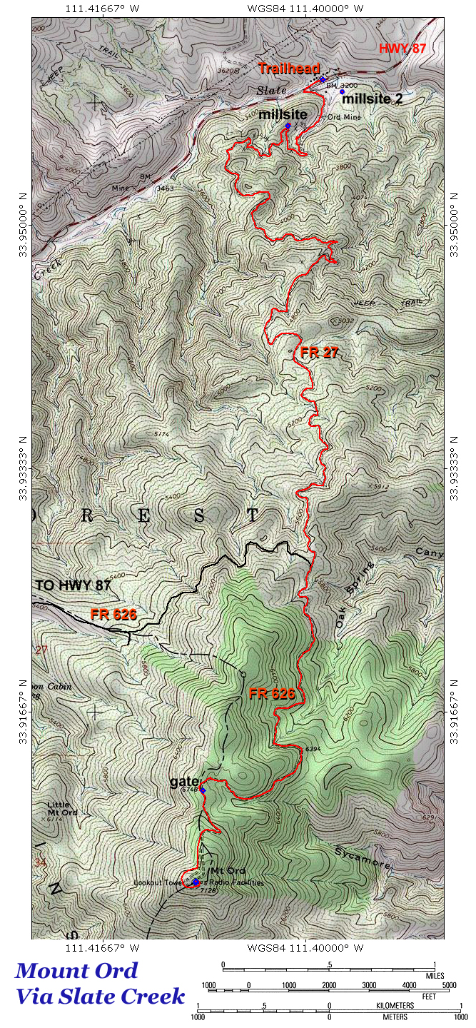
At the very bottom of Slate Creek Canyon, there is a small pullout on the south side of the northbound lanes of state highway 87. This will be mile 0.0 for this hike. Forest Road 27, which this hike follows, immediately doubles back to the west to parallel the highway for several hundred feet before passing through a fence and crossing the heavily eroded wash of Slate Creek. Forest Road 27 then makes a sharp turn to the east to begin a steep climb up the velvety green, chaparral clad north slope of Mount Ord.
The hike soon turns south to ascend a small side canyon of colorful purplish slate, clothed in bluish-green Arizona cypress trees. This is the Ord Mine area. Across the canyon on a sloping bench is the former site of the second Ord Mill, which processed mercury ore from the mine. The road continues up the little canyon and tops out on a small hill, near some old concrete foundations. This is the site of the original 1926 mill. Numerous old mine trails crisscross the hill, leading to collapsed shafts and overgrown adits. Be careful around the crumbling shafts.
Around mile 1.3, the road leaves the Ord Mine area behind and renews its vigorous climb up the mountainside. The Beeline Highway shrinks into the bottom of Slate Creek Canyon, while steadily increasing views stretch from Saddle Mountain on the west to the Sierra Ancha on the east. A few tiny spur ridges provide small campsites on the otherwise steep and heavily vegetated north slope of Mount Ord.
As the hike approaches the 5000-foot level, Forest Road 27 rolls across a small flat, where Mazatzal Peak and the Mogollon Rim can be seen rising to the north. Soon after, the first ponderosa makes an appearance.
After climbing past a jagged ridge of reddish rock, Forest Road 27 reaches a junction at 5 miles with the new Mount Ord Road (Forest Road 626). Continue south along Forest Road 626, as it climbs Oak Spring Canyon onto the ponderosa pine cloaked upper slopes of Mount Ord.
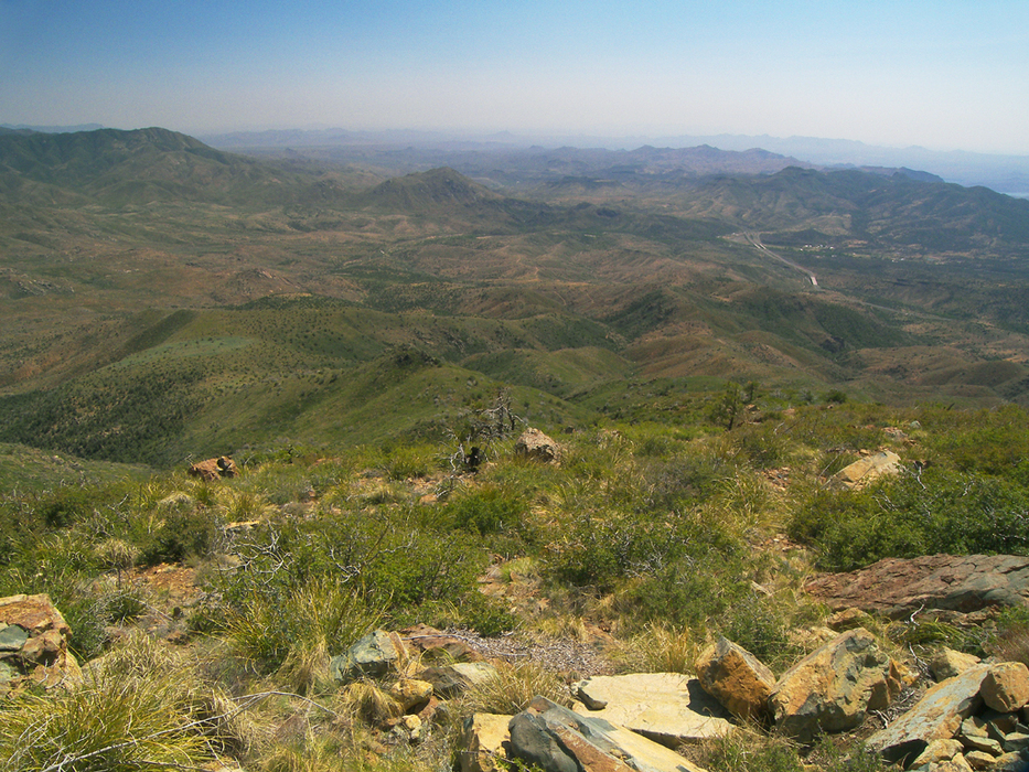
As the road crests Oak Spring Ridge, the mountain falls away to reveal an outstanding view of Four Peaks and Tonto Basin. Beyond this point, the road wraps around the upper end of Sycamore Canyon, where it reaches a large parking area in a saddle, at 7 miles. At this point, a locked vehicle barrier gate blocks the road. Hike past the gate.
Now in a forest of mature Gambel oaks, Forest Road 626 makes a broad switchback and arrives at a fork at 7.35 miles. Both forks lead to the summit, but the right (west) fork has better views. This road wraps around the south side of the peak and finally comes to an end at 7.75 miles, amid the many communication towers crowning Mount Ord's windswept summit. The 102-foot fire tower sits on top of the true summit. The forest service discourages visitors from climbing the tower, but there are incredible views to be found from ground level anywhere on the peak. All of central Arizona is spread out before you.
Return the way you came. The views are even better on the return trip.
Gate Policy: If a gate is closed upon arrival, leave it closed after you go through. If it is open, leave it open. Leaving a closed gate open may put cattle in danger. Closing an open gate may cut them off from water. Please be respectful, leave gates as found. The exception is signage on the gate directing you otherwise.
WARNING! Hiking and outdoor related sports can be dangerous. Be responsible and prepare for the trip. Study the area you are entering and plan accordingly. Dress for the current and unexpected weather changes. Take plenty of water. Never go alone. Make an itinerary with your plan(s), route(s), destination(s) and expected return time. Give your itinerary to trusted family and/or friends.
Permit $$
None
Directions
Road
Paved - Car Okay
To hike Slate Creek Trailhead: From Phoenix, take state highway 87 north to the bottom of Slate Creek Canyon (4.8 miles past the signed Mount Ord turnoff at the Maricopa/Gila County line). Turn right into a large pull-off/parking area at milepost 228.7 at the bottom of Slate Creek Canyon. The hike begins here (see hike description) ***NOTE: If heading southbound on Highway 87 from Payson, you will have to continue past the bottom of Slate Creek Canyon to the divided highway crossover at the Maricopa/Gila County line! ***
Upper Access: From Phoenix, take state highway 87 north to the signed turnoff for Mt. Ord Road, about 0.5 miles north of milepost 222 (near Maricopa/Gila County line). Turn right, and follow Mt. Ord Road/forest road 626 to its end at a locked gate, about 5.8 miles from Highway 87.
page created by PrestonSands on Jun 13 2008 3:44 pm
 Route Editor


 Overview
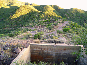


