 Route Editor

| Guide | ♦ | 19 Triplogs | 0 Topics |
details | drive | no permit | forecast | 🔥 route |
stats |
photos | triplogs | topics | location |
| 173 | 19 | 0 |
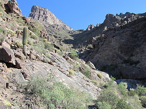
 2023 Warning 2023 WarningParking at the originally suggested spot or in the neighborhood period may be a gamble for a ticket or a tow. Obey city/state/federal signage. Overview: Although there is some semblance of a trail occasionally, one should approach this as an off-trail bushwhack. It involves some scrambling and bouldering and gets into areas few others have been. Check out the Official Route and Triplogs. Leave No Trace and +Add a Triplog after your hike to support this local community. One-Way Notice This hike is listed as One-Way. When hiking several trails on a single "hike", log it with a generic name that describes the hike. Then link the trails traveled, check out the example. | |||||||||||||||||||||||||||||||||||||||||||||||||||||||||||||||||||||||||||||||||||||||||||||||


