 Route Editor

| Guide | ♦ | 1 Triplog | 0 Topics |
details | drive | no permit | forecast | map |
stats |
photos | triplog | topics | location |
| 18 | 1 | 0 |
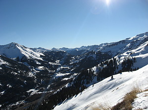
Aspen and Views by Jim The Richmond trail starts on US 550, just south of the popular tourist town of Ouray, and near the historic town of Ironton. The trail is signed and easy to find. Once on the trail, it is a series of switchbacks up an aspen covered slope. In fall, this must be a very popular or at least colorful hike. As you gain elevation, the aspen thin out and the spruce come to dominate. Eventually, you're in meadows and these give way to open alpine grass and flower covered slopes. A short side trip to point 12,170 can provide an easy peak, as well as canyon views. The trail continues on to Richmond Pass. The trail leading up to the pass crosses a northeast facing slope which will hold snow into early summer, so plan accordingly. It is also an avalanche path in winter.
Check out the Triplog. Leave No Trace and +Add a Triplog after your hike to support this local community. One-Way Notice This hike is listed as One-Way. When hiking several trails on a single "hike", log it with a generic name that describes the hike. Then link the trails traveled, check out the example. | ||||||||||||||||||||||||||||||||||||||||||||||||||||||||||||||||||||||||||||||||||||||||||


