 Route Editor

| Guide | ♦ | 6 Triplogs | 0 Topics |
details | drive | no permit | forecast | 🔥 route |
stats |
photos | triplogs | topics | location |
| 124 | 6 | 0 |
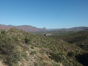
Skip the Verde Crossing by jacobemerick  Overview OverviewAs the Verde River Trail heads north it crosses the river twice, once at Red Creek Rapids and then again near Pete's Cabin Mesa. These crossings are difficult during any time of the year and may become threatening during high water events - so, this trail, combined with a section of Wet Bottom, can be used to avoid the crossings. Highwater Trail can also be combined with other trails to create enjoyable loops in the Mazatzal lowlands. Hike Reaching the trailhead is a small adventure in itself. The most direct method would be to take FR18 down to Red Creek, follow Red Creek to the Verde River, cross it, and then hike up to the start. Otherwise, starting from Sheep Bridge, it is an eight-mile walk along the Verde River and a few miles up Wet Bottom Trail. Either way, the trailhead is located in a shallow depression on top of the Wet Bottom Mesa and is marked by a weathered sign.
Once past the creek, the tread may be difficult to pick up, as the route sticks to the sandy flats next to the Verde and has no cairns to guide a way forward. This section only lasts a few hundred yards and, at the next drainage, a path leads away from the sandy flats and onto the rocky land above. At 2 miles there are another few washes to pass under those white bluffs that were visible earlier and a slight climb around the back of them. Once on the back of those bluffs feel free to look back south and try to pick out where on Wet Bottom Mesa this trail dropped down, it's a good vantage. The rest of the route is fairly nondescript. There are a few easy wash crossings, and Squaw Butte becomes more prominent to the north, and the tread is easy to follow along the relatively flat ground. Around the 3-mile mark, Pete's Cabin Mesa begins and the vegetation becomes lush and verdant, though the trail remains well-defined throughout. On old topo maps, the junction with Verde River Trail forms a small triangle - however, the bottom leg of this triangle is incredibly overgrown and not worth attempting. Stick to the cairns and stay on the top of the triangle to reach the proper end of Highwater. From here one can either head south towards Red Creek or continue north to Twin Buttes. Water Sources Canyon Creek may have water a short distance up the creek from the trail crossing. Otherwise, there is always the Verde, which is easily accessed a few times along the route, though the taste may be off-putting. Camping There are no defined campsites along the route. Several flat pads could work, especially along the Verde River near Canyon Creek and the white bluffs. Check out the Official Route and Triplogs. Leave No Trace and +Add a Triplog after your hike to support this local community. One-Way Notice This hike is listed as One-Way. When hiking several trails on a single "hike", log it with a generic name that describes the hike. Then link the trails traveled, check out the example. | ||||||||||||||||||||||||||||||||||||||||||||||||||||||||||||||||||||||||||||||||||||||||||||||||||||||||||||||||||||||||||||||||||||||||||||||||||||||||||||||||||||||||||


