 Route Editor

| Guide | 0 Triplogs | 0 Topics |
details | drive | no permit | forecast | route |
stats |
photos | triplogs | topics | location |
| 30 | 0 | 0 |
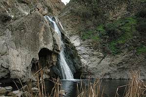
seven creek crossings by slegal  The eastern end of the trail begins where the Fort Trail and the Las Flores Trail meet. Just a few yards west the Trail meets the Gold Canyon Trail, just before the trail makes the first of seven creek crossings. The second creek crossing is just 40 yards away.
After a little more than a third of a mile you'll reach the Meadows Cave. On either side of the Meadows Cave are junctions with the San Miguel Trail and the Indian Creek Trail. Just past the Indian Creek Trail the Trail makes its third creek crossing, this time over Indian Creek rather than Arroyo Conejo. Immediately after making the Indian Creek crossing the trail meets with the public access road that provides one of the access routes for park vehicles. The Wildwood Canyon Trail makes a left turn at this junction. The trail continues for a little less than a quarter mile to a junction with both the Lynnmere Trail and the Tepee Trail. Continuing down the trail you approach the area that most people visit the canyon for - the waterfalls. The first is Little Falls located near a small picnic area. The trail then climbs uphill along a steep section of the canyon's north wall. The trail then descends above Paradise Falls, the main attraction in the park. The next trail junction is the Paradise Falls Trail. After passing the falls the trail travels about a quarter mile to a creek crossing that brings you to a large picnic area called Oak Grove. The junction with the Eagle Point Trail is in Oak Grove. About 50 yards later is another creek crossing. The trail continues another 50 yards to a junction with the Tepee Trail. A few yards past the junction is another creek crossing. After the creek crossing the trail becomes a single track trail. After 20 yards the trail makes the last of seven creek crossings. The remainder of the trail travels along the north side of the creek. After a little over a tenth of a mile the trail meets with the Eagle Point Trail. If you look up the canyon wall to the north you can see the Mesa trail 600 feet up, just before is reaches the Lizard Rock Trail. The Trail map suggests that the Wildwood Canyon Trail ends at the junction with the Eagle Point Trail. I consider the end of the Wildwood Canyon Trail to be where the Trail meets the pavement at the gate to the Hill Canyon Water Treatment Facility. Therefore, continuing past the Eagle Point Trail it's about a quarter mile to the junction with the Lizard Rock Trail, to the right. The final section of trail is not very exciting as it travels just above the sewage treatment plant until it ends at Hill Canyon Road just past the gate to the facility. Gate Policy: If a gate is closed upon arrival, leave it closed after you go through. If it is open, leave it open. Leaving a closed gate open may put cattle in danger. Closing an open gate may cut them off from water. Please be respectful, leave gates as found. The exception is signage on the gate directing you otherwise. Check out the Official Route. Leave No Trace and +Add a Triplog after your hike to support this local community. One-Way Notice This hike is listed as One-Way. When hiking several trails on a single "hike", log it with a generic name that describes the hike. Then link the trails traveled, check out the example. | ||||||||||||||||||||||||||||||||||||||||||||||||||||||||||||||||||||||||||||||||||


