As you may have guessed the highlights of this hike are the great views of the Pacific Ocean. The hike starts in Frank Valley which was formerly used by the military as part of the harbor defenses of San Francisco. Though there was no visible evidence of the military activity which ended after World War 2, Frank Valley used to sport underground bunkers that were fire control stations for artillery at Fort Barry and also the command-detonated minefields off the coast. Today Frank Valley holds a small trailhead, a few picnic tables, and a huge meadow with a horse arena. The entire hike is within Mount Tamalpais State Park.
The hike starts by walking southwest through the meadow to the horse arena about 300 yards from the trailhead, then turning right onto the Heather Cut-Off Trail. Heather Cut-Off gently winds 1.2 miles and 450 feet up a series of switchbacks to its junction with the Coast View Trail on top of a large ridge. The Heather Cut-Off Trail travels through a nice stretch of coast chaparral which is sometimes referred to as "soft" chaparral because there are no spines or scratchy leaves that make one's legs look like this: https://hikearizona.com/photo.php?ZIP=223450 . Indeed one could easily walk through the stuff if it weren't full of large spiders.
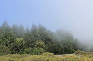
The Coast View Trail heads straight up the ridge for 2.5 miles from the junction until it reaches a junction with the Dipsea Trail. You've traveled 3.7 miles to this point, and the Dipsea Trail offers opportunities to either head west and down to Stinson Beach or east to Muir Woods for longer journeys. Coast View offers great views of the Pacific Ocean to the west, but the views are better on the way down. There are very few trees here to obscure the view. Redwoods make their first appearance halfway up, but most trees are Douglas fir gnarled by coastal weather or California bays.
This trip tops off at Pantoll Ranger Station at 1,500' in the cool pines. Return the way you came.
WARNING! Hiking and outdoor related sports can be dangerous. Be responsible and prepare for the trip. Study the area you are entering and plan accordingly. Dress for the current and unexpected weather changes. Take plenty of water. Never go alone. Make an itinerary with your plan(s), route(s), destination(s) and expected return time. Give your itinerary to trusted family and/or friends.
Permit $$
None
Directions
Road
Paved - Car Okay
To hike Take US Highway 1 from US Highway 101 roughly 20 miles west of the 101 to the Muir Woods Road. Frank Valley is approximately 1 mile north on Muir Woods Road from Highway 1. Parking consists of about 10 spots adjacent to the trailhead.
page created by JimmyLyding on Feb 13 2012 9:21 pm
 Route Editor