 Route Editor

| Guide | ♦ | 7 Triplogs | 0 Topics |
details | drive | permit | forecast | map |
stats |
photos | triplogs | topics | location |
| 11 | 7 | 0 |
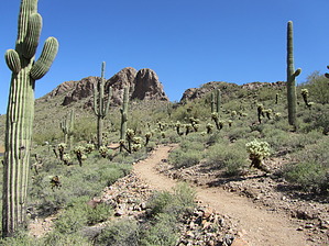
 There are several short, interesting, well-groomed trails originating from this trailhead. All are very short and in addition, there is access to a variety of bushwhacks, peak bagging, and rock climbing access from this trailhead. The well-marked trails include Sunset Loop, Risky Business Loop, and Deer Point. This is an urban hike but great for an in-town hike with fantastic panoramic sunset views of the Valley of the Sun and surrounding points of interest. There are several short, interesting, well-groomed trails originating from this trailhead. All are very short and in addition, there is access to a variety of bushwhacks, peak bagging, and rock climbing access from this trailhead. The well-marked trails include Sunset Loop, Risky Business Loop, and Deer Point. This is an urban hike but great for an in-town hike with fantastic panoramic sunset views of the Valley of the Sun and surrounding points of interest. Check out the Triplogs. Leave No Trace and +Add a Triplog after your hike to support this local community. One-Way Notice This hike is listed as One-Way. When hiking several trails on a single "hike", log it with a generic name that describes the hike. Then link the trails traveled, check out the example. | |||||||||||||||||||||||||||||||||||||||||||||||||||||||||||||||||||


